Doi Tung
| Doi Tung | |
|---|---|
 Doi Tung Thailand | |
| Highest point | |
| Elevation | 1,389 m (4,557 ft) |
| Listing | Buddhist temples on mountaintops in Thailand |
| Coordinates | 20°20′45″N 99°50′04″E / 20.34583°N 99.83444°ECoordinates: 20°20′45″N 99°50′04″E / 20.34583°N 99.83444°E |
| Geography | |
| Location | Chiang Rai (Thailand) |
| Parent range | Doi Nang Non, Daen Lao Range |
| Geology | |
| Mountain type | granite |
| Climbing | |
| Easiest route | drive |
Doi Tung (ดอยตุง) is a mountain in the Thai highlands of Chiang Rai Province, Thailand.
Location
While not the highest elevation of the province, the 1,389 m high Doi Tung rises steeply close to the Thailand-Myanmar border. It is the highest point of the Doi Nang Non, a subrange of the Daen Lao Range, in the area known as "Golden Triangle".[1]
Description
Most of the bedrock of the mountain is limestone and granite. The vegetation below 1,000 m is mostly deciduous forest, and the vegetation above this height is evergreen.[2]
The population of Doi Tung is about 11,000 people, consisting of various tribes including Akha, Lahu, Tai Lue, and Lawa.[3]
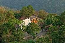
Wat Phra That Doi Tung is on top of the hill. According to the chronicles, this Buddhist place of worship dates back to the year 911. It is an important pilgrimage spot for the devout.
Economy
Coffee plantations cover an area of 15 km2. There are 3.5 million coffee trees on Doi Tung. Almost half of Doi Tung's population is in coffee farming, providing a stable source of income for nearly 900 families.[3]
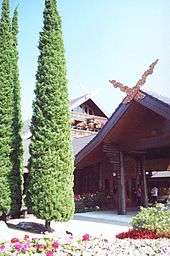
Doi Tung Royal Villa
The Doi Tung royal villa, former residence of the princess mother Srinagarindra is also high up on the hill.
Thanks to the princess mother's interest and encouragement, the hills were reforested.[3] She was also instrumental in fighting against the opium trade, as a result the local hilltribes stopped growing poppies and began to grow other crops.[4]
The royal villa was originally built as a summer residence for the princess mother and now houses a museum and displaying her work to improve the life quality of local tribal people.[5]
The Mae Fah Luang Gardens are a botanical park on the slopes below the royal villa. Flowers and plants grow among rock formations.
See also
References
- ↑ Google Earth
- ↑ J. F. Maxwell, Vegetation of Doi Tung, Chiang Rai Province Archived February 23, 2012, at the Wayback Machine.
- 1 2 3 Promchertchoo, Pichayada (24 March 2018). "From one addiction to another: Thailand's ethnic minorities quit opium for coffee". Channel News Asia. Retrieved 24 March 2018.
- ↑ Mae Fah Luang Foundation Archived April 8, 2009, at the Wayback Machine.
- ↑ Doi Tung - Chiang Rai - Overview