Doi Mae Salong
| Doi Mae Salong | |
|---|---|
| ดอยแม่สลอง | |
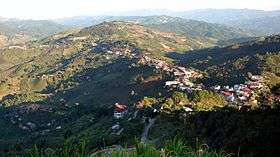 Doi Mae Salong and Santikhiri town on the ridge | |
| Highest point | |
| Elevation | 1,367 m (4,485 ft) [1] |
| Listing | List of mountains in Thailand |
| Coordinates | 20°10′06″N 99°37′10″E / 20.16833°N 99.61944°ECoordinates: 20°10′06″N 99°37′10″E / 20.16833°N 99.61944°E [2] |
| Geography | |
 Doi Mae Salong | |
| Parent range | Daen Lao Range |
| Climbing | |
| First ascent | unknown |
| Easiest route | Hike or drive from Santikhiri |
Doi Mae Salong (Thai: ดอยแม่สลอง) is a mountain in Thailand, part of the Daen Lao Range. It is in the northern part of Chiang Rai Province six km from the border with Burma.
This mountain rises in Mae Fa Luang District. Its summit is near the town of Santikhiri which is built on the ridge.[3]
This mountain is famous because a Kuomintang military division created a settlement near it in 1961 after having been expelled from Burma.[4]
See also
References
- ↑ Google Earth
- ↑ Google Earth
- ↑ Doi Mae Salong
- ↑ Bangkok Post - Doi Mae Salong
External links
This article is issued from
Wikipedia.
The text is licensed under Creative Commons - Attribution - Sharealike.
Additional terms may apply for the media files.