Doi Ang Khang
| Doi Ang Khang | |
|---|---|
 Doi Ang Khang Thailand | |
| Highest point | |
| Elevation | 1,400 m (4,600 ft) |
| Coordinates | 19°54′1.2″N 99°2′21.5″E / 19.900333°N 99.039306°ECoordinates: 19°54′1.2″N 99°2′21.5″E / 19.900333°N 99.039306°E |
| Geography | |
| Location | Ban Khum Village, Mu 5, Mae Ngon Sub district, Amphoe Fang, Chiang Mai Province |
| Parent range | Daen Lao Range |
| Geology | |
| Mountain type | Limestone |
| Climbing | |
| Easiest route | drive |
Doi Ang Khang (Thai: ดอยอ่างขาง) is a mountain in Fang District, Chiang Mai Province, Thailand. It is part of the Daen Lao Range that straddles both sides of the Burmese-Thai border. It is the site of an agricultural station, the first research station set up by King Bhumibol Adulyadej in 1969.[1] The peak of Doi Ang Khang is 1,928 metres (6,325 ft) above sea level, and the agricultural station covers an area of 1,989 rai (318 ha).[2]
Climate
The temperature average is 17.7 °C. The highest temperatures range from 35-38 °C in April. The lowest temperature recorded is -3 °C in January. The rainfall average is 2,075 mm per year.[2]
| Climate data for Doi Ang Khang (1981–2010) | |||||||||||||
|---|---|---|---|---|---|---|---|---|---|---|---|---|---|
| Month | Jan | Feb | Mar | Apr | May | Jun | Jul | Aug | Sep | Oct | Nov | Dec | Year |
| Average high °C (°F) | 20.0 (68) |
23.0 (73.4) |
26.2 (79.2) |
27.4 (81.3) |
24.3 (75.7) |
24.0 (75.2) |
22.9 (73.2) |
22.4 (72.3) |
22.6 (72.7) |
21.6 (70.9) |
19.8 (67.6) |
18.7 (65.7) |
22.7 (72.9) |
| Average low °C (°F) | 13.0 (55.4) |
15.0 (59) |
17.5 (63.5) |
18.6 (65.5) |
17.6 (63.7) |
17.8 (64) |
17.7 (63.9) |
17.7 (63.9) |
17.5 (63.5) |
16.8 (62.2) |
14.3 (57.7) |
12.6 (54.7) |
16.3 (61.3) |
| Average relative humidity (%) | 64 | 47 | 46 | 59 | 80 | 85 | 88 | 91 | 88 | 88 | 77 | 73 | 74 |
| Mean monthly sunshine hours | 272.8 | 240.1 | 275.9 | 243.0 | 198.4 | 159.0 | 161.2 | 158.1 | 183.0 | 198.4 | 249.0 | 251.1 | 2,590 |
| Mean daily sunshine hours | 8.8 | 8.5 | 8.9 | 8.1 | 6.4 | 5.3 | 5.2 | 5.1 | 6.1 | 6.4 | 8.3 | 8.1 | 7.1 |
| Source: Office of Water Management and Hydrology, Royal Irrigation Department[3] | |||||||||||||
Ang Khang Royal Agricultural Station
The agricultural station researches and cultivates temperate climate fruits, flowers, and vegetables. At present, the station has more than 12 species of temperate fruits such as raspberries, peaches, plums, kiwis, and strawberries, and more than 60 species of vegetables such as carrots, Brussels sprouts, and peas, and more than 50 species of temperate flowers such as carnations and roses.[2]
Gallery

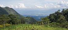 Fang Valley from one of the two access roads to Doi Ang Khang
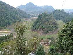 Ang Khang Royal Agricultural Station
Travel
How to travel to Doi Ang Khang?
From Bangkok to Chiangmai
By Public transportation
1. Airplane
- Depart from Suvarnabhumi Airport to Chiangmai Airport
- Depart from Donmuang Airport to Chiangmai Airport
2.Train
- Depart from Hua-lamphong railway station to Chiangmai railway station
3.Bus
- Depart from Mochit-2 transport station to Chuang Phuak transport station
From Chaingmai to Doi Ang Khang
By Public transportation
When you arrive at Chiangmai airport and Chiangmai railway station you have to call taxi or red bus to go to Chuang Phuak transport station. From there depart Chuang Phuak transport station to Fang district by bus or van. You should getout of the bus or van at Hat Samran temple. At Hat samran temple there are songthaew taxis to go to Doi Ang Khang.[4]
By Personal car
There are 2 routes to go to Doi Ang Khang
1.First route begins by taking highway 107 north out of Chiangmai for 130 kilometers to Hat Samran temple. From here about 25 kilometers on the steep highway 1249 to Doi Ang khang. But highway 1249 is not suggested to inexperienced drivers and small-engine cars.[5]
2.Second route begins by taking highway 107 north out of Chiangmai to Chiang-Dao district and taking highway 1178 on the north side of Chiang-Dao. After 40 kilometers, there is a turn off for highway 1340. This joins Highway 1249 a few kilometers short of Doi Ang Khang.
This rout is less steep than the first route.[5]
References
- ↑ Dawson, Alan (24 December 2017). "Living the high life". Bangkok Post. Retrieved 24 December 2017.
- 1 2 3 "Location, Weather, Population". RAS, Ang Khang, About Us. Royal Agricultural Station Ang Khang. Retrieved 2014-11-24.
- ↑ "ปริมาณการใช้น้ำของพืชอ้างอิงโดยวิธีของ Penman Monteith (Reference Crop Evapotranspiration by Penman Monteith)" (PDF) (in Thai). Office of Water Management and Hydrology, Royal Irrigation Department. p. 15. Retrieved 31 July 2016.
- ↑ "สถานีเกษตรหลวงอ่างขาง | Travel". www.angkhangstation.com. Retrieved 2018-05-05.
- 1 2 "DoiAngKhangChiangmai". www.whatsup-chiangmai.com/attractions/ang-khang/. Retrieved 2018-04-01.
External links
| Wikimedia Commons has media related to Doi Ang Khang. |

- Doi Ang Khang Station