Dobrzyniec
| Dobrzyniec | |
|---|---|
| Village | |
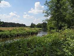 Świder in Dobrzyniec | |
 Dobrzyniec | |
| Coordinates: 52°6′48″N 21°27′34″E / 52.11333°N 21.45944°E | |
| Country |
|
| Voivodeship | Masovian |
| County | Otwock |
| Gmina | Kołbiel |
Dobrzyniec [dɔˈbʐɨɲet͡s] is a village in the administrative district of Gmina Kołbiel, within Otwock County, Masovian Voivodeship, in east-central Poland.[1] It lies approximately 6 kilometres (4 mi) north of Kołbiel, 14 km (9 mi) east of Otwock, and 34 km (21 mi) east of Warsaw.
References
| Seat |  | |
|---|---|---|
| Other villages | ||
This article is issued from
Wikipedia.
The text is licensed under Creative Commons - Attribution - Sharealike.
Additional terms may apply for the media files.