District 9, Düsseldorf
| Stadtbezirk 9 | |
|---|---|
| District of Düsseldorf | |
.jpg) Park and Schloss Benrath in Düsseldorf-Benrath | |
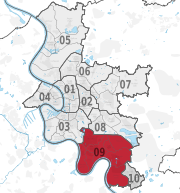 Location of District 9 shown in red | |
| Country |
|
| State |
|
| City |
|
| Area | |
| • Total | 36.59 km2 (14.13 sq mi) |
| Population (December 2009[1]) | |
| • Total | 89,163 |
| • Density | 2,437/km2 (6,310/sq mi) |


District 9 (German: Stadtbezirk 9) is a southern city district of Düsseldorf, the state capital of North Rhine-Westphalia, Germany. The district covers an area of 36,59 square kilometres and (as of December 2009) has about 89,000 inhabitants.
The district borders with the Düsseldorf districts 3 and 8 to the North, and 10 to the South. To the East and West the district borders with the rural districts of Kreis Mettmann and Rhein-Kreis Neuss respectively.
Subdivisions
District 9 is made up of eight Stadtteile (city parts):
| # | City part | Population (2009) | Area (km²) | Pop. per km² | |
|---|---|---|---|---|---|
| 091 | Düsseldorf-Benrath | 15,831 | 5,90 | 2,683 | |
| 092 | Düsseldorf-Hassels | 17,538 | 4,50 | 3,897 | |
| 093 | Düsseldorf-Himmelgeist | 1,302 | 4,46 | 292 | |
| 094 | Düsseldorf-Holthausen | 11,846 | 5,30 | 2,235 | |
| 095 | Düsseldorf-Itter | 1,717 | 2,61 | 658 | |
| 096 | Düsseldorf-Reisholz | 3,604 | 1,78 | 2,025 | |
| 097 | Düsseldorf-Urdenbach | 10,490 | 7,64 | 1,373 | |
| 098 | Düsseldorf-Wersten | 26,788 | 4,38 | 6,116 | |
| source: Amt für Statistik und Wahlen der Landeshauptstadt Düsseldorf (in German) | |||||
Places of interest
Landmarks
- Park and Schloss Benrath, Benrath, Park and Castle
- St. Hubertus, Itter, romanesque church from 12th century
- St. Nikolaus, Himmelgeist, romanesque church from 11th century
Parks and open spaces
- Schlosspark Benrath
- Südpark
- Botanic Garden of Düsseldorf University
Transportation
The district is served by numerous railway stations and highway.[2] Stations include Düsseldorf-Benrath, Düsseldorf-Reisholz and both Düsseldorf Stadtbahn light rail- and Rheinbahn tram-stations. The district can also be reached via Bundesautobahn 46 and 59 as well as Bundesstraße 8 and 228.
See also
References
- ↑ Stadtbezirk 9 Archived June 26, 2011, at the Wayback Machine., Landeshauptstadt Düsseldorf, 2009 (in German)
- ↑ Urban rail-transitmap Düsseldorf-Meerbusch Archived December 23, 2010, at the Wayback Machine., Verkehrsverbund Rhein-Ruhr
External links
![]()
- Official webpage of the district (in German)
|  | |
| ||
Coordinates: 51°10′40″N 6°51′28″E / 51.17778°N 6.85778°E