Dinwiddie, Virginia
| Dinwiddie, Virginia | |
|---|---|
| Unincorporated community | |
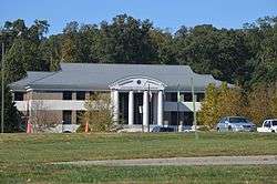 Current courthouse, seen from U.S. Route 1 | |
 Dinwiddie  Dinwiddie | |
| Coordinates: 37°04′41″N 77°35′12″W / 37.07806°N 77.58667°WCoordinates: 37°04′41″N 77°35′12″W / 37.07806°N 77.58667°W | |
| Country | United States |
| State | Virginia |
| County | Dinwiddie |
| Elevation | 840 ft (256 m) |
| Time zone | UTC-5 (EST) |
| • Summer (DST) | UTC-4 (EDT) |
| Area code(s) | 804 |
| GNIS feature ID | 1498473[1] |
Dinwiddie is a small unincorporated community and the county seat of Dinwiddie County, Virginia, United States.[2][1]
History
The town was the site of the Battle of Dinwiddie Court House, the Battle of Five Forks as well as the Battle of Sutherland's Station during the Appomattox Campaign.
Geography
The town is near the Interstate 85 corridor, about halfway between Richmond and the North Carolina State line.
Main sights
Burnt Quarter, the Dinwiddie County Court House, and Williamson Site are listed on the National Register of Historic Places.[3]
References
- 1 2 "Dinwiddie, Virginia". Geographic Names Information System. United States Geological Survey.
- ↑ "Find a County". National Association of Counties. Archived from the original on 2011-05-31. Retrieved 2011-06-07.
- ↑ National Park Service (2010-07-09). "National Register Information System". National Register of Historic Places. National Park Service.
External links
![]()
Municipalities and communities of Dinwiddie County, Virginia, United States | ||
|---|---|---|
| Town |  | |
| Unincorporated communities | ||
This article is issued from
Wikipedia.
The text is licensed under Creative Commons - Attribution - Sharealike.
Additional terms may apply for the media files.