Deusto
| Deusto | |
|---|---|
| District | |
 Deusto district is highlighted in blue in this map of the districts of Bilbao. | |
| Country | Spain |
| Autonomous community | Basque Country |
| Province | Biscay |
| Comarca | Greater Bilbao |
| Municipality | Bilbao |
| Area | |
| • Total | 4.95 km2 (1.91 sq mi) |
| Population (2016) | |
| • Total | 48,933 |
| • Density | 9,900/km2 (26,000/sq mi) |
Deusto (or Deustu) is a district of the city of Bilbao (Biscay), in the Spanish Basque Country on the right bank of the Estuary of Bilbao. It includes the neighbourhoods of Arangoiti, Ibarrekolanda, San Ignacio-Elorrieta and San Pedro de Deusto-La Rivera, with a total population of 48,933. It used to be a separate municipality until it was incorporated in 1925. The traditional center has always been at the Church of St. Peter. The neighbourhood is linked to downtown Bilbao by a bascule bridge.
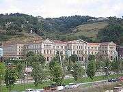
Currently it hosts one of the most important Jesuit Universities: the University of Deusto.
In the 1960s the Deusto Canal was excavated, the shore of Deusto was to become an artificial island with facilities for the Port of Bilbao. The project was abandoned before its end when it became obvious that bringing more ships to the city would be impractical. The neighbourhood Zorrozaurre then became a separate, artificially created peninsula.
As a rural municipality Deusto produced tomatoes of local renown, and its residents are still nicknamed tomateros.
Sights


Districts of Bilbao | ||
|---|---|---|
|  | |
Coordinates: 43°16′20″N 2°56′45″W / 43.27222°N 2.94583°W