Derrintony
Derrintony is a townland in the Civil Parish of Tomregan, Barony of Knockninny, County Fermanagh, Northern Ireland.
Etymology
The townland name is an anglicisation of the Gaelic placename “Doire an Tonnaigh” which means ‘The Oakwood of the Rampart’. The oldest surviving mention of the name is in a grant dated 14 October 1612 where it is spelled ‘Derrintory’. Spellings in later grants are 1629 – Derrenteine, 1747- Dirintony & Derrintony, 1753- Derrintony, 1759- Derrintony and 1767- Derrintony.[1]
Geography
It is bounded on the north by Drumshimuck townland, on the east by Drumany More and Derryart townlands, on the south by Garvary townland and on the west by Aghindisert, Gortaree and Aghintra townlands. Its chief geographical features are the Duvoge River and a drumlin hill reaching to 70 metres above sea-level.
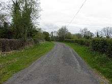
The townland is traversed by Derrintony Lane.
Derrintony covers an area of 148 statute acres.
History
The townland formed part of the ballybethagh of Calvagh in medieval times. At the beginning of the 17th century it was owned jointly by Bryan McPhilip O’Reyly and Edward Rutlidge but was confiscated by the Crown in the 1609 Ulster Plantation and it formed part of the half-territory of Aughrin which was granted to Sir Hugh Culme in 1610. Culme later relinquished his claim to the Crown, perhaps because there was confusion at the time as to whether the townland formed part of County Fermanagh or County Cavan. By an order of the Lord Deputy dated 14 October 1612 the townland was granted, inter alia, to Lady Margaret O’Neill, the widow of Sir Hugh Maguire deceased. In 1641 and also in 1670 it was owned by Sir William Balfour (general).[2]
The Tithe Applotment Books for 1827 list the following tithepayers in the townland- Fawcett, Curry, McAvinue.[3]
In 1841 the population of the townland was 36, being 15 males and 21 females. There were five houses in the townland, all were inhabited.[4]
In 1851 the population of the townland was 26, being 10 males and 16 females, the reduction being due to the Great Famine (Ireland). There were four houses in the townland, all were inhabited.[5]
Griffith's Valuation of 1857 lists fifteen occupiers in the townland.[6]
In 1861 the population of the townland was 43, being 23 males and 20 females. There were nine houses in the townland and all were inhabited.[7]
In 1871 the population of the townland was 30, being 15 males and 15 females. There were five houses in the townland and all were inhabited.(page 606 of census)[8]
In 1881 the population of the townland was 25, being 11 males and 14 females. There were five houses in the townland, all were inhabited.[9]
In 1891 the population of the townland was 16, being 7 males and 9 females. There were five houses in the townland, one of which was uninhabited.[10]
In the 1901 census of Ireland, there are five families listed in the townland.[11]
In the 1911 census of Ireland, there are five families listed in the townland.[12]
Antiquities
The only historic site in the townland is an old foot-stick over the Duvoge River.
References
- ↑ http://www.placenamesni.org/historicforms.php?getPnameId=13803
- ↑ Settlement on a Plantation Estate, the Balfour Rentals of 1632 and 1636 by John Johnston, in Clogher Record Vol. 12, No. 1 (1985), pp. 92-109
- ↑ Tithe Applotment Books 1827
- ↑
- ↑
- ↑ Derrintony "Griffith's Valuation 1857".
- ↑
- ↑
- ↑
- ↑
- ↑ Census of Ireland 1901
- ↑ Census of Ireland 1911
External links