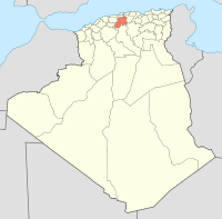
Derrag
| Derrag | |
|---|---|
| Commune and town | |
 Kherbat Siouf in Derrag | |
 | |
 Derrag | |
| Coordinates: 35°54′31″N 2°23′16″E / 35.90861°N 2.38778°E | |
| Country |
|
| Province | Médéa Province |
| Population (1998) | |
| • Total | 7,695 |
| Time zone | UTC+1 (CET) |
Derrag is a town and commune in Médéa Province, Algeria. According to the 1998 census it has a population of 7,695.[1]

The village of Derrag is located on the southern side of the Tellian Atlas, west of the Oursenis and at an altitude of 1,150 meters.
It is nestled in a very small area called Bled Derrag of about 128 km2, a small geographical entity inserted in a corner between the forests of Chaoun and Boumedienne and separated from the high plateaux by the Taguensa and djebel Azzeba. It occupies a surface bordered on both sides by well-watered mountains, and on a third by the steppe.
Djebel Chaoun culminates at 1820 meters marks the tripoint between the wilayas of Medea, Tissemsilt and Ain Defla. The region is essentially constituted by a framework represented by masses encircling a central zone of vacuum which is itself nipple-shaped.
In the north the Boumediene (1,648 m) in the west is the Chaoun (1.804 m) and the Techta (1,687 m), and finally on the south-west, northeast face the jebel Azzeba (1,386 m) And the Tagensa 1,710 m).
The central part, with a less pronounced relief, nevertheless contains some eminences: Djiret, Kef touil, Chebaret. The orographic system belongs to that of Ouarsenis and the region is part of the "Chain of Limes". The declivity of land is almost universal. As a result, they are unfavorable to mechanization and susceptible to erosion.
Hydrography
The peripheral mountains play the part of water-castles, and the country constitutes an impluvium. Sources are numerous, but their flow is always low (Aîn Endis, the largest has a flow of 6 liters / second at low water). They have drinking water, more or less calcareous. Sometimes, to the east, in the marls, the waters charge some magnesia, for the most part they are usable.
However, some areas are poorly equipped or lack water resources.
History
The region of Bled Derrag was attached to the mixed commune of Theniet El Had at the beginning of the colonization where will be created from the colonial village of Letourneux in 1891, which will pass under the authority of the mixed-commune of Boghari until 1956 Where it becomes a full-function commune separated from Siouf. In 1963, it will be integrated into the newly created municipality of Aziz, the municipality will be reborn in 1984 under the name Derrag.
