Deichselbach
| Deichselbach | |
|---|---|
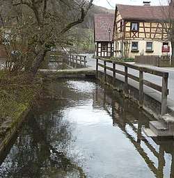 The Deichselbach in Frankendorf | |
| Location |
Upper Franconia, Bavaria, |
| Reference no. | DE: 242912 |
| Physical characteristics | |
| Main source |
near the village Tiefenhöchstadt in the community of Buttenheim ca. 477 m above sea level (NN) |
| River mouth |
near Altendorf into the Regnitz ca. 245 m above sea level (NN) 49°47′50″N 10°59′54″E / 49.7972°N 10.9982°ECoordinates: 49°47′50″N 10°59′54″E / 49.7972°N 10.9982°E |
| Length | 12.1 km (7.5 mi) [1] |
| Basin features | |
| Progression | Regnitz→ Main→ Rhine→ North Sea |
The Deichselbach is a stream in Upper Franconia, Germany. It is about 12 kilometers long.
Course
The Deichselbach has its source east of the village Tiefenhöchstadt in the community of Buttenheim. In Altendorf, the stream passes under the Rhine–Main–Danube Canal and then flows into the Regnitz.
The stream runs through the following places:
- Tiefenhöchstadt
- Frankendorf
- Stackendorf
- Gunzendorf (constituent community of Buttenheim)
- Dreuschendorf
- Buttenheim
- Altendorf
References
- ↑ Complete table of the Bavarian Waterbody Register by the Bavarian State Office for the Environment (xls, 10.3 MB)
| Wikimedia Commons has media related to Deichselbach (Regnitz). |
This article is issued from
Wikipedia.
The text is licensed under Creative Commons - Attribution - Sharealike.
Additional terms may apply for the media files.