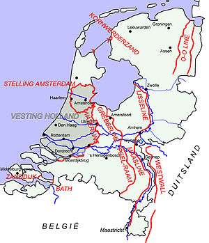
Defence lines of the Netherlands
Roman Defence Line
- Upper German Limes Limes Germanicus
Pre 1874 Defence Lines
- Circumvallatielinie van Groenlo [1][2]
- Frisian Water Line (Friese Waterlinie)
- Groningse Waterlinie
- Helperlinie
- Linie Bergen op Zoom - Steenbergen
- Linie van Beverwijk
- Linie van de Eems
- Linie van de Eendracht
- Linie van Noord-Holland
- Oostfrontier
- Hollandic Water Line (Oude Hollandse Waterlinie)
- Positie van 's-Hertogenbosch
- Posten van Krayenhoff
- Staats - Spaanse Linies
- Stelling West Noord-Brabant
- Zijper Stelling
- Zuider Frontier
Fortification Law 1874
The Vestingwet[3] (eng: Fortification Law) or Wet tot regeling en voltooiing van het vestingstelsel (eng: Law to regulate and complete the fortification) was signed on 18 April 1874. The law dealt with the defence of the Netherlands against enemy attacks.
The main principle was defence by flooding where as the army of the Netherlands would withdraw to the area around Amsterdam. After the Franco-Prussian War (1870–1871) it became clear that a new defence plan was needed. The law was made by the Minister of War August Weitzel under King Willem III. The Law became dysfunctional at 28 March 1938.
- Grebbe Line (Grebbelinie)[4]
- IJssel Line (IJssellinie)
- New Hollandic Line (Nieuwe Hollandse Waterlinie)
- Defence Line of Amsterdam (Stelling van Amsterdam)[5]
- Stelling van Den Helder
- Stelling van het Hollandsch Diep en het Volkerak
- Stelling van de monden der Maas en van het Haringvliet
- Werken aan de Westerschelde
- Zuiderwaterlinie
Interbellum (1918 - 1940)
- Bath & Zanddijk Stellingen
- Geullinie
- Grebbe Line (Grebbelinie)
- IJssel Line (IJssellinie)
- Kazematten Afsluitdijk
- Maaslinie
- Linge - Waallinie
- Oranjestelling
- Peel-Raam Line (Peel-Raamstelling)
- Waal-Maaslinie
- Weerstandslinies Noord-Oost Nederland
World War II (1939 - 1945)
During the occupation of the Netherlands, the Germans made fortifications to prohibit the Allies to liberate the Netherlands and to protect their V2 rocket platforms in the Netherlands. The Germans built new defence lines like the Atlantic Wall but also reused the Dutch defence line like the Grebbe line.
- Assenerstellung / Frieslandriegel
- Atlantic Wall (Atlantikwall)
- Brabantstellung
- Vordere Wasserstellung
- Hintere Wasserstellung
- Panther Line (Pantherstellung) [6]
- IJsselstellung
Cold War (1946 - 1991)
During the cold war a defence line was created to slow down the Russian attack on the Netherlands.[7]
- IJssel Line (IJssellinie) (1953–1964)
Maps of the Defence Lines
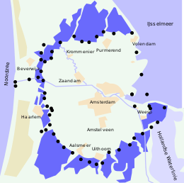 Stelling van Amsterdam
Defence line of Amsterdam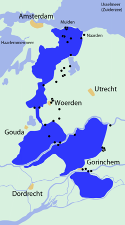 Oude Nederlandse waterlinie
Hollandic Water Line Nieuwe Nederlandse waterlinie
New Hollandic Water Line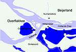 Stelling van het Hollands Diep en Volkerak
Defence line of Hollands Diep en Volkerak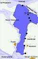 West Brabantse waterlinie
West Brabentse Water line Grebbelinie
Grebbe line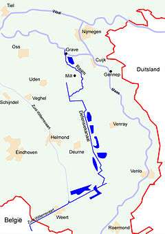 Peel-Raamstelling
Peel-Raam line_1627_-_Grolla_Obsessa_et_Expugnata_(J.Blaeu).jpg) Circumvallatielinie van Groenlo
Circumvallatielinie van Groenlo
Circumvallation of Groenlo Atlantikwall
Atlantic Wall
References
- ↑ http://www.engelseschans.nl/ Site with English summary
- ↑ http://www.circumvallatielinie.nl/ Dutch site with new discovered parts of the line
- ↑ http://www.forten.info/index.htm?http://www.forten.info/wetten/vestingwet.htm Text of the Fortification Law
- ↑ http://www.grebbelinie.nl/ Dutch site of the Grebbe Line
- ↑ http://www.stelling-van-amsterdam.nl/?art_id=57 English information about the Defence Line of Amsterdam
- ↑ http://www.grebbelinie.nl/page/pantherstellung Dutch information about the Pantherstellung
- ↑ http://www.ijssellinie.nl/ENGELS/index.html English information about the IJssel Line