Phoenix Deer Valley Airport
| Phoenix Deer Valley Airport | |||||||||||||||
|---|---|---|---|---|---|---|---|---|---|---|---|---|---|---|---|
_Terminal-1975.jpg) Phoenix Deer Valley Airport Terminal | |||||||||||||||
| Summary | |||||||||||||||
| Airport type | Public | ||||||||||||||
| Owner | City of Phoenix | ||||||||||||||
| Serves | Phoenix, Arizona | ||||||||||||||
| Built | 1960 | ||||||||||||||
| Elevation AMSL | 1,478 ft / 450 m | ||||||||||||||
| Coordinates | 33°41′18″N 112°04′57″W / 33.68833°N 112.08250°WCoordinates: 33°41′18″N 112°04′57″W / 33.68833°N 112.08250°W | ||||||||||||||
| Website | https://deervalleyairport.com | ||||||||||||||
| Runways | |||||||||||||||
| |||||||||||||||
| Statistics (2011) | |||||||||||||||
| |||||||||||||||
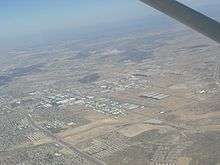
Phoenix Deer Valley Airport (IATA: DVT, ICAO: KDVT, FAA LID: DVT) is a public airport 17 miles (15 nmi; 27 km) north of Phoenix, in Maricopa County, Arizona. It is owned by the City of Phoenix.[1] The FAA's National Plan of Integrated Airport Systems for 2009–2013[4] categorized it as a reliever airport for Phoenix Sky Harbor International Airport.[1]
In 2010 the airport recorded 368,747 aircraft movements, making it the 25th busiest airport in the world by aircraft movements and the busiest general aviation airport in the world.[5]
Usage
There is no scheduled airline, but charter service is available through several companies, including one charter airline, Westwind Air Service.[6]
Training
Facilities and aircraft
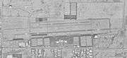
The airport covers 914 acres (370 ha) at an elevation of 1,478 feet (450 m). It has two asphalt runways: 7R/25L is 8,196 by 100 feet (2,498 x 30 m) and 7L/25R is 4,500 by 75 feet (1,372 x 23 m).[1]
In 2008 the airport had 376,504 aircraft operations, average 1,031 per day: 65% general aviation, 35% military and <1% airline. 987 aircraft were then based at the airport: 85% single-engine, 10% multi-engine, 2% jet, 2% helicopter, <1% glider, and <1% military.[1]
Incidents and accidents
- On August 20, 2018, an accident occurred when an Acroduster airplane crashed at Seventh Street near the airport as it was trying to land on it, killing 54 year old pilot Theodore Rich and his 49 year old passenger, Elaine Carpenter.[7]
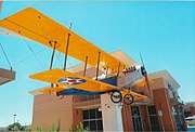
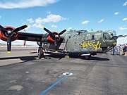
Gallery
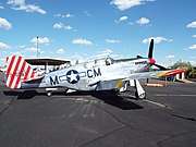
Phoenix Deer Valley Airport has hosted various air shows of vintage World War II aircraft's. Among the events which have taken place there is "Wings of Freedom".
_Monument-1975.jpg)
-1944-1.jpg)
-1944-2.jpg)

References
- 1 2 3 4 5 FAA Airport Master Record for DVT (Form 5010 PDF). Federal Aviation Administration. Effective 29 July 2010.
- ↑ 2009 Busiest Airports by Aircraft Movements Archived 2009-01-01 at the Wayback Machine.
- ↑ Airport IQ 5010, Phoenix Deer Valley Airport
- ↑ National Plan of Integrated Airport Systems for 2009–2013: Appendix A: Part 1 (PDF, 1.33 MB). Federal Aviation Administration. Updated 15 October 2008.
- ↑ http://www.aci.aero/Data-Centre/Annual-Traffic-Data/Movements/2010-final
- ↑ https://www.westwindairservice.com
- ↑ https://www.azcentral.com/story/news/local/phoenix-breaking/2018/08/20/small-plane-crashes-near-deer-valley-airport/1040859002/
External links
- Plane Crash at Deer Valley - Aug 4, 2010
- Phoenix Deer Valley Airport, official site
- Phoenix Deer Valley Airport at Arizona DOT website
- Deer Valley Pilots Association
- Phoenix Flyers Flying Club
- Westwind School of Aeronautics
- TransPac Aviation Academy
- Westwind Air Service (charters)
- FAA Airport Diagram (PDF), effective October 11, 2018
- FAA Terminal Procedures for DVT, effective October 11, 2018
- Resources for this airport:
- FAA airport information for DVT
- AirNav airport information for KDVT
- ASN accident history for DVT
- FlightAware airport information and live flight tracker
- NOAA/NWS latest weather observations
- SkyVector aeronautical chart, Terminal Procedures
- OpenNav airspace and charts for KDVT