Deer Mountain (Alaska)
| Deer Mountain | |
|---|---|
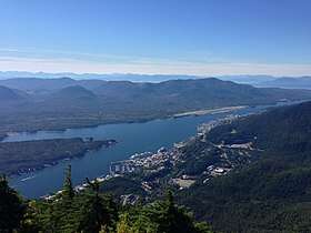 A view of Ketchikan, Alaska looking northwest from the summit of Deer Mountain. | |
| Highest point | |
| Elevation | 2,697 ft (822 m) [1] |
| Coordinates | 55°20′36″N 131°35′57″W / 55.34333°N 131.59917°WCoordinates: 55°20′36″N 131°35′57″W / 55.34333°N 131.59917°W [1] |
| Geography | |
 Deer Mountain Location of Deer Mountain in Alaska | |
| Location | Tongass National Forest, Ketchikan Gateway Borough, Alaska, US |
| Parent range | Coast Mountains |
| Topo map | USGS Ketchikan B-5 |
| Climbing | |
| Easiest route | Deer Mountain National Recreation Trail |
Deer Mountain is a 2,697 feet (822 m) mountain peak located in the Tongass National Forest in the Ketchikan Gateway Borough, Alaska, which dominates the skyline behind downtown Ketchikan.[1][2] The Deer Mountain National Recreation Trail provides a strenuous hiking route to the summit, passing through temperate rainforests, muskeg and alpine meadows as it gains 2,600 feet (790 m) of elevation over 2.75 miles (4.43 km) from the trailhead in Ketchikan to the peak.[3]
References
- 1 2 3 "Deer Mountain". SummitPost.org. Retrieved 2013-09-14.
- ↑ "Deer Mountains". Geographic Names Information System. United States Geological Survey. Retrieved 2013-09-14.
- ↑ Ketchikan Area Trails Guide, Tongass National Forest, R10-RG-210, February 2013
This article is issued from
Wikipedia.
The text is licensed under Creative Commons - Attribution - Sharealike.
Additional terms may apply for the media files.