Deer Island Waste Water Treatment Plant
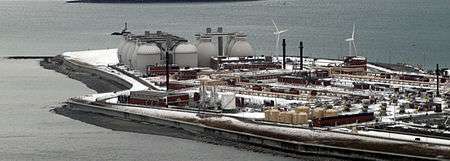
The Deer Island Waste Water Treatment Plant (also known as Deer Island Sewage Treatment Plant) is located on Deer Island, one of the Boston Harbor Islands in Boston Harbor. The plant is operated by the Massachusetts Water Resources Authority (MWRA) and began partial operations in 1995. The facility was fully operational in 2000 with the completion of the outfall tunnel.[1]
Deer Island is the second largest sewage treatment plant in the United States.[2] The plant is a key part of the program to protect Boston Harbor from pollution from sewer systems in eastern Massachusetts, mandated by a 1984 federal court ruling by Judge Paul G. Garrity, in a case brought under the Clean Water Act.[3][4]
From the 1880s until 1991, the northeastern side of the island was the location of the Deer Island Prison.
History
The first sanitary sewer system for the Boston area, serving eighteen cities and towns, opened in 1884. It collected raw sewage on Moon Island in the harbor, and discharged it 500 feet off shore, with the ebbing tide.[1]
In 1889, the Metropolitan Sewerage District was established. Over the next fifteen years, the agency built one of the finest regional sewerage systems in the country, although it still discharged the raw sewage into the ocean.[1]
By 1940 there were three points, on Nut, Deer, and Moon islands, for the discharge of raw sewage into the Atlantic Ocean.[1] This sewage had contaminated the shellfish beds to the point that discussions of building treatment plants began. The Nut Island plant opened in 1951. The Deer Island plant opened in 1968, and the Moon Island plant was converted to standby, overflow, operation.[1]
The Metropolitan Sewerage District was reorganized into the MWRA, a larger agency, in 1985.[1] Under the federal court order,[3] MWRA completely rebuilt the treatment system between 1985 and 2000.[1] Subsequently all sewage is treated and the effluent is discharged at the sea floor 9.5 miles (15.3 km) from shore.[1][2][5]
Before the new plant fully opened in 2000, the Deer Island plant had average flow capacity of 343 mgd (million gallons per day), and peak flow capacity of 848 mgd. The system had combined sewer overflows an average of 60 days per year, with a total of about 10 billion gallons per year of untreated sewage flowing into Boston Harbor. The new plant has a peak capacity of 1.2 billion gal/day, with average flows of 380 mgd, and no raw sewage discharges.[6]
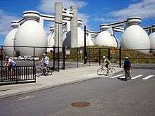
The plant uses a 10-mile long gravity-powered outfall tunnel that bores underneath the bay towards the ocean. It is one of the longest underwater tunnels in the world. In the last mile of the tunnel are 52 mushroom-shaped riser pipes that carry treated effluent up from the tunnel to the ocean floor, where it is dispersed. Two divers died in the final phase of construction in 1999.[7]
References
| Wikimedia Commons has media related to Deer Island Waste Water Treatment Plant. |
- 1 2 3 4 5 6 7 8 "A History of the Sewer System". Boston, MA: Massachusetts Water Resources Authority. Retrieved 2017-11-10.
- 1 2 "The Center for Land Use Interpretation". Ludb.clui.org. Retrieved 11 November 2017.
- 1 2 Steindorf, Sara (2005-05-05). "Professor touts Boston Harbor cleanup as victory of judiciary." Harvard Law School News.
- ↑ Saxon, Wolfgang (24 August 2004). "Paul Garrity, 66, Boston Judge Who Left a Cleaner Harbor". Nytimes.com. Retrieved 11 November 2017.
- ↑ "MWRA's Massachusetts Bay page". Mwra.state.ma.us. Retrieved 11 November 2017.
- ↑ Keay, K., and W. Leo. "Contingency Plan." MWRA. Rep. N.p., n.d. 28 June 2014.
- ↑ Swidey, Neil (2014). "Trapped Under the Sea: One Engineering Marvel, Five Men, and a Disaster Ten Miles Into the Darkness."
External links
- "Boston Harbor Cleanup." Civil Engineering. (08857024) 72.11/12 (2002): 168. 25 June 2014.
- "The Boston Harbor Project: an Environmental Success Story". MWRA. 2014-12-16.
- Garcia, Enrique Alonso; Vicente-Arche, Ana Recarte (January 2005). The Boston Harbor Project (PDF) (Report). Alcalá de Henares, Spain: Friends of Thoreau Environmental Program; University of Alcalá.
Coordinates: 42°21′2.53″N 70°57′26.29″W / 42.3507028°N 70.9573028°W