Dednja Vas
| Dednja Vas | |
|---|---|
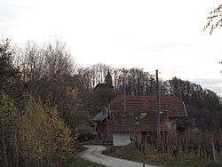 View of St. Barbara's Church in Blatno from Dednja Vas | |
 Dednja Vas Location in Slovenia | |
| Coordinates: 45°58′42.55″N 15°38′25.82″E / 45.9784861°N 15.6405056°ECoordinates: 45°58′42.55″N 15°38′25.82″E / 45.9784861°N 15.6405056°E | |
| Country |
|
| Traditional region | Styria |
| Statistical region | Lower Sava |
| Municipality | Brežice |
| Area | |
| • Total | 2.7 km2 (1.0 sq mi) |
| Elevation | 245.4 m (805.1 ft) |
| Population (2002) | |
| • Total | 174 |
| [1] | |
Dednja Vas (pronounced [ˈdeːdnja ˈʋaːs]; Slovene: Dednja vas, German: Dittmannsdorf[2]) is a settlement in the Municipality of Brežice in eastern Slovenia. The area was traditionally part of Styria. It is now included with the rest of the municipality in the Lower Sava Statistical Region.[3]
The local church, built on a hill above the settlement, is dedicated to the Holy Cross and belongs to the Parish of Pišece. It is a Gothic building with ribbed vaults and trefoil mouldings on its windows. It was remodelled in the 18th century, but still retains these original features.[4]
References
- ↑ Statistical Office of the Republic of Slovenia
- ↑ Leksikon občin kraljestev in dežel zastopanih v državnem zboru, vol. 4: Štajersko. 1904. Vienna: C. Kr. Dvorna in Državna Tiskarna, p. 8.
- ↑ Brežice municipal site
- ↑ Slovenian Ministry of Culture register of national heritage reference number 3247
External links

- Dednja Vas on Geopedia

%2C_Bre%C5%BEice.jpg)
This article is issued from
Wikipedia.
The text is licensed under Creative Commons - Attribution - Sharealike.
Additional terms may apply for the media files.