De Pere Lock and Dam Historic District
|
De Pere Lock and Dam Historic District | |
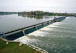 De Pere Dam | |
| Location | Fox R. at James St., De Pere, Wisconsin |
|---|---|
| Coordinates | 44°26′58″N 88°03′47″W / 44.44944°N 88.06306°WCoordinates: 44°26′58″N 88°03′47″W / 44.44944°N 88.06306°W |
| Area | 2.8 acres (1.1 ha) |
| MPS | Waterway Resources of the Lower Fox River MPS |
| NRHP reference # | 93001331[1] |
| Added to NRHP | December 7, 1993 |
The De Pere Lock and Dam Historic District is located in De Pere, Wisconsin.[2] It was added to the State Register of Historic Places in 1992 and to the National Register of Historic Places the following year.[3]
References
- ↑ National Park Service (2010-07-09). "National Register Information System". National Register of Historic Places. National Park Service.
- ↑ "De Pere Lock Keeper's House". Wisconsin Historical Markers. Retrieved 2018-04-03.
- ↑ "DE PERE LOCK AND DAM". Wisconsin Historical Society. Retrieved 2018-04-03.
This article is issued from
Wikipedia.
The text is licensed under Creative Commons - Attribution - Sharealike.
Additional terms may apply for the media files.