Dawson Street
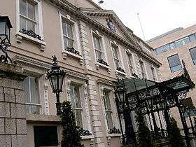
Dawson Street (Irish: Sráid Dhásain) is one of the main streets of central Dublin.
The street was named after Joshua Dawson who laid out Dawson Street as well as the nearby Grafton, Anne, and Harry Streets,[1] and who built the Mansion House in 1710.[2]
Location
Dawson Street runs parallel to Grafton Street, to which it is connected by Duke Street and South Anne Street. Much of the street is a shopping thoroughfare, including the bookshop Hodges Figgis.
Molesworth Street links the street to Kildare Street.
Saint Ann's Church is found on the eastern side and the Mansion House near the south end.
The street has a slight slope downwards from its Stephen's Green end to its Trinity end.
Traffic flows one way, northwards.
Famous inhabitants
Noted Irish ecclesiastical architect William Hague had his office at 50 Dawson Street.[3] As did Thomas Francis McNamara (also at No. 50 and No. 5).
Luas
| Luas Cross City | ||||||||||||||||||||||||||||||||||||||||||||||||||||||||||||||||||||||||||||||||||||||||||||||||||||||||||||||||||||||||||
|---|---|---|---|---|---|---|---|---|---|---|---|---|---|---|---|---|---|---|---|---|---|---|---|---|---|---|---|---|---|---|---|---|---|---|---|---|---|---|---|---|---|---|---|---|---|---|---|---|---|---|---|---|---|---|---|---|---|---|---|---|---|---|---|---|---|---|---|---|---|---|---|---|---|---|---|---|---|---|---|---|---|---|---|---|---|---|---|---|---|---|---|---|---|---|---|---|---|---|---|---|---|---|---|---|---|---|---|---|---|---|---|---|---|---|---|---|---|---|---|---|---|---|
|
Green Line extension | ||||||||||||||||||||||||||||||||||||||||||||||||||||||||||||||||||||||||||||||||||||||||||||||||||||||||||||||||||||||||||
| ||||||||||||||||||||||||||||||||||||||||||||||||||||||||||||||||||||||||||||||||||||||||||||||||||||||||||||||||||||||||||
Dawson Street is a stop on the Luas Cross City Line. The line links the Red and Green lines going from Broombridge in North Dublin (interchange with Irish Rail station) and St.Stephen's Green Green Line stop. Construction started in June 2013 with services beginning on 9 December 2017.[4][5]
See also
References
- ↑ Irish Place and Street Names
- ↑ Dictionary of Ulster Biography
- ↑ Gerry Convery. Poetry in Stone: Sacred Heart Church. (Omagh: Drumragh RC Parish, 1999), p.57
- ↑ "Green light given to Luas link-up, first passengers 2017". RTÉ. Archived from the original on 5 August 2012. Retrieved 5 August 2012.
- ↑ "Taoiseach launches new Luas Cross City service in Dublin". RTÉ. 9 December 2017. Retrieved 9 December 2017.
External links