Dawa River
| Dawa River | |
|---|---|
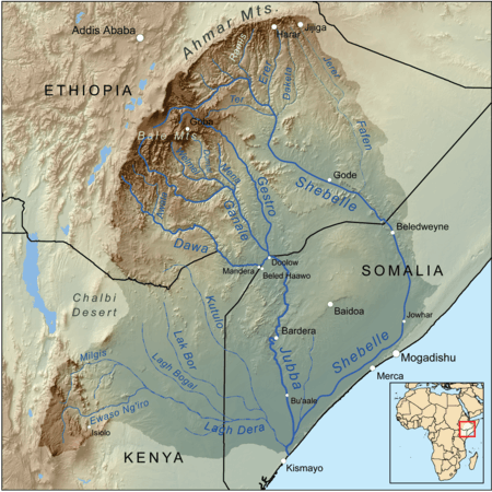 Map of the Jubba/Shebelle drainage basin | |
| Country | Ethiopia, Somalia, Kenya |
| Physical characteristics | |
| River mouth |
into Jubba River 4°10′39″N 42°04′47″E / 4.1774°N 42.0796°ECoordinates: 4°10′39″N 42°04′47″E / 4.1774°N 42.0796°E |
The Dawa River is a perennial river in southeastern Ethiopia. Rising in the mountains east of Aleta Wendo, the Dawa flows south and east to join with the Ganale Dorya at the border with Somalia to become the Jubba. The river forms part of the Ethiopia–Somalia border and part of the Ethiopia–Kenya border.
The river valley is relatively wide, with gently sloping sides of exposed bedrock. The lower part flows through a valley which would be classed as a relatively young erosion cycle. Prospectors have found gold along the Dawa between the Awata and Kojowa tributaries. The titanium minerals rutile and ilmenite were found by geologists working for the Texas Africa Exploration Company in 1958.[1]
Notes
- ↑ "Local History in Ethiopia" (pdf) The Nordic Africa Institute website (accessed 5 May 2011)
This article is issued from
Wikipedia.
The text is licensed under Creative Commons - Attribution - Sharealike.
Additional terms may apply for the media files.