Daund taluka
| Daund taluka दौंड तालुका | |
|---|---|
| Taluka | |
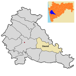 Location of Daund in Pune district in Maharashtra | |
| Coordinates: 18°27′47″N 74°34′44″E / 18.4631°N 74.5789°ECoordinates: 18°27′47″N 74°34′44″E / 18.4631°N 74.5789°E | |
| Country |
|
| State | Maharashtra |
| District | Pune district |
| Headquarters | Daund |
| Government | |
| • Lok Sabha constituency | supriya sule |
| • Assembly constituency | Rahul shubhash kul |
| Area | |
| • Taluka | 1,290 km2 (500 sq mi) |
| Population (2011)[1] | |
| • Taluka | 382,535 |
| • Density | 300/km2 (770/sq mi) |
| • Urban | 56,436 |
Daund taluka is a taluka or subdivision of Pune district of state of Maharashtra in India. The town of Daund is the only major urban area in this predominantly rural area. Daund railway station is a major railway junction.All southern railways Reached to this route, and also divided the Nager railway to north India railway, like Delhi. Solapur division daund junction next joined to pune district junction. To reached siddhi vinayak siddhatek ganpati traveling 14 km to daund by road.
In the winter above temperature 19 to 20℃ has the mostly agricultural production of sugarcane. The riverbank farmers are mostly taken sugarcane Seasonal. The back water of UJANI DAM riverbed region has acacia tree forest. Thorn containing tree founded much more. 3 sugar factory available in daund 1)daund sugar limited.alegaon2)bhima patas patas 3)anuraj sugar limited.yavat.
See also
- Talukas in Pune districteast at ahmednagar district,karjat-jamkhed taluka.
- Deulgaon Gada
The daund taluka and pune district divided by bhima river divided in next ahmednagar district.Gardening house part of daund people on this bhima river. The bhima river joined many of sub-river.some villages are getting the back water of UJANI DAM .