Daubenhorn
| Daubenhorn | |
|---|---|
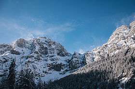 Daubenwall in february of 2014 | |
| Highest point | |
| Elevation | 2,942 m (9,652 ft) |
| Prominence | 92 m (302 ft) [1] |
| Isolation | 0.66 kilometres (0.41 mi) |
| Parent peak | Wildstrubel |
| Coordinates | 46°23′21.6″N 7°36′09.3″E / 46.389333°N 7.602583°ECoordinates: 46°23′21.6″N 7°36′09.3″E / 46.389333°N 7.602583°E |
| Geography | |
 Daubenhorn Location in Switzerland | |
| Location | Valais, Switzerland |
| Parent range | Bernese Alps |
Located above the Swiss town of Leukerbad, the Daubenhorn is a mountain in the Bernese Alps. The mountain has the longest via ferrata, or secured climbing route, in Switzerland.[2] The route is built into the mountain's southeastern face and continues to the summit.
This via ferrata is considered to be extremely difficult (ED) and requires very good fitness to make the 6 hour climb to the summit from the base of the Via Ferrata at 2350 m.[3] In addition, it is also possible to reach the summit by trekking a circuitous route starting from Gemmi Pass.
Footnotes
- ↑ Retrieved from the Swisstopo topographic maps. The key col is located south of the summit at 2,850 m.
- ↑ "The longest fixed-rope climbing route in Switzerland, Summer 13". leukerbad.ch. Leukerbad Tourismus. Archived from the original on 12 March 2014.
- ↑ "517 Viaferrata Loeche, Loeche, Valais, Suisse". viaferrata.org (in French). Archived from the original on 8 October 2011.
External links
- Daubenhorn hikr.org
This article is issued from
Wikipedia.
The text is licensed under Creative Commons - Attribution - Sharealike.
Additional terms may apply for the media files.