Darp
| Darp | |
|---|---|
| Town | |
 | |
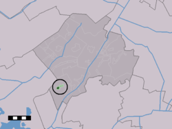 The town centre (dark green) and the statistical district (light green) of Darp in the municipality of Westerveld. | |
| Coordinates: 52°46′30″N 6°12′13″E / 52.77500°N 6.20361°ECoordinates: 52°46′30″N 6°12′13″E / 52.77500°N 6.20361°E | |
| Country | Netherlands |
| Province | Drenthe |
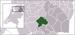
| Municipality | Westerveld |
| Population | |
| • Total | 550 |
| Time zone | UTC+1 (CET) |
| • Summer (DST) | UTC+2 (CEST) |
Darp is a small town in the Dutch province of Drenthe. In 2001, the town of Darp had 507 inhabitants. It is a suburb of the municipality of Westerveld, and lies about 19 km west of Hoogeveen.
The built-up area of the town was 0.17 km², and contained 189 residences.[1]
The statistical area, "Darp", which can also include the surrounding countryside, has a population of around 580.[2]
References
- ↑ Statistics Netherlands (CBS), Bevolkingskernen in Nederland 2001 Archived March 19, 2006, at the Wayback Machine.. (Statistics are for the continuous built-up area).
- ↑ Statistics Netherlands (CBS), Statline: Kerncijfers wijken en buurten 2003-2005 Archived 2006-07-24 at WebCite. As of 1 January 2005.
This article is issued from
Wikipedia.
The text is licensed under Creative Commons - Attribution - Sharealike.
Additional terms may apply for the media files.