Darfur Dome
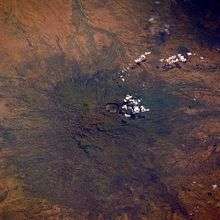
The Darfur Volcanic Province from ISS.
Darfur Dome or Darfur Volcanic Province is an area about 100x400 km in area in Western Sudan, the result of a volcanic plume[1][2] which created its best-known and central feature, Deriba Crater. It also produced the surrounding Marra Mountains (Jebel Marra)[3][4] and Tagabo Hills, formed around 16 and 10 Ma., and the Meidob Hills which arose around 6.8 Ma.[5] The plume is linked to stress resolution along the Central African Fault Zone.
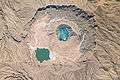 Deriba Caldera
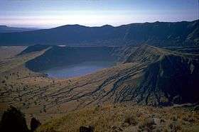 Jebel Marra Deriba Lakes
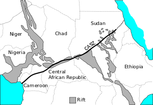 Central Africa showing CASZ.
Notes
- ↑ "The Darfur Dome, western Sudan: the product of a subcontinental mantle plume", G. Franz, International Journal of Earth Sciences, Volume 83, Number 3 / October, 1994
- ↑ Franz, G (1999), "Plume related alkaline magmatism in central Africa—the Meidob Hills (W Sudan)", Chemical Geology, 157: 27–47, doi:10.1016/S0009-2541(98)00195-8
- ↑ Google Maps
- ↑ "Jebel Marra, a dormant volcano in Darfur Province, Western Sudan", J. R. Vail, Bulletin of Volcanology, Volume 36, Number 1 / March, 1972
- ↑ G. Franz
Coordinates: 13°5′0″N 24°20′0″E / 13.08333°N 24.33333°E
This article is issued from
Wikipedia.
The text is licensed under Creative Commons - Attribution - Sharealike.
Additional terms may apply for the media files.