Dampier Archipelago
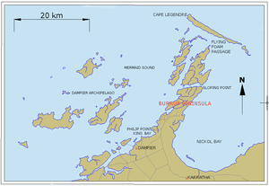
The Dampier Archipelago is a group of islands near Dampier, Western Australia. It is named after William Dampier, an English buccaneer and explorer who visited in 1699. Dampier named one of the islands, Rosemary Island.
History
The largest island (or peninsula) in the group was known as Murujuga by the earliest inhabitants, the Yaburara (or Jaburara) people.[1] The first British settlers renamed it Dampier Island and it was later officially renamed Burrup Peninsula.
Marine resources
Despite being a region through which considerable shipping and industrial activity occurs, the archipelago has considerable marine resources.[2]
Indigenous heritage
In 1868, the area was the site of the Flying Foam massacre, in which between 20 and 150 members of the Yaburara are reported to have been killed.
Notes
- ↑ "AusAnthrop Australian Aboriginal tribal database - Jaburara". AusAnthrop. Archived from the original on 2009-03-17. Retrieved 2008-06-21.
- ↑ Jones, Diana S. Dampier Archipelago down under. Landscope (Como, W.A.), Summer 2003, p. 47-52
References
- Chittleborough, R. G.,The Dampier Archipelago marine study : a progress report, Perth, W.A.: Dept.of Conservation and Environment, Bulletin 141. 1983.