Damghan County
| Damghan County شهرستان دامغان | |
|---|---|
| County | |
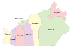 Semnan counties | |
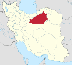 Location of Semnan Province in Iran | |
| Coordinates: 35°30′N 54°20′E / 35.500°N 54.333°ECoordinates: 35°30′N 54°20′E / 35.500°N 54.333°E | |
| Country |
|
| Province | Semnan Province |
| Capital | Damghan |
| Bakhsh (Districts) | Central District, Amirabad District |
| Population (2006) | |
| • Total | 81,993 |
| Time zone | UTC+3:30 (IRST) |
| • Summer (DST) | UTC+4:30 (IRDT) |
| Damghan County can be found at GEOnet Names Server, at this link, by opening the Advanced Search box, entering "9206415" in the "Unique Feature Id" form, and clicking on "Search Database". | |
Damghan County (Persian: شهرستان دامغان) is a county (shahrestan) in Semnan Province, Iran. The capital of the county is Damghan. At the 2006 census, the county's population was 81,993, in 23,020 families.[1]
City and towns
Damghan County consists of two districts (bakhshes): Central District and Amirabad District. The Central District has three cities: Damghan, Dibaj, and Kalateh Rudbar. The Ali Spring (Cheshmeh-ye Ali) is located there, not be confused with the Cheshmeh-ye Ali in Rey, south Tehran. The Amirabad District forms the major part of the county. The only city is Amiriyeh, located southwest of Damghan.
Other important villages in the county are: Mehmandust, Naimabad, Tazareh, Tuyeh & Darvar, Qusheh, Hasanabad, and Rashm.
History
The area suffered damage in the 856 Damghan earthquake.
Tourist attractions
Damghan city itself has many ancient and historical places. However outside the city also there are some attractions like:
- Toghrol Tower in Mehmandust
- Ali Spring (Cheshmeh Ali) and its fort
- Dibaj, Sarcheshmeh and Imamzadeh
- Abbasi Carvansaray
- Gerd Kuh
- Mansurkuh and Mehrnegar
- Cheshmeh & Tom of Baba Ali in north of Naim Abad
- Dam on Damghan River
- Dasht-e Kavir
Transport
Main Tehran-Mashhad railway is 5 km south of Damghan. Damghan is alongside of Tehran-Mashhad Highway. From south there is main road to Isfahan and Yazd, and northward from Ali Spring (Cheshmeh Ali) & Tuyeh Darvar to Sari and through Dibaj to Behshahr & Gorgan.
See also
References
- ↑ "Census of the Islamic Republic of Iran, 1385 (2006)". Islamic Republic of Iran. Archived from the original (Excel) on 2011-11-11.
- اطلس گیتاشناسی استانهای ایران [Atlas Gitashenasi Ostanhai Iran] (Gitashenasi Province Atlas of Iran)
- Damghan News Agency
| Capital |  | ||||||||||||||||
|---|---|---|---|---|---|---|---|---|---|---|---|---|---|---|---|---|---|
| Counties and cities |
| ||||||||||||||||
| Sights |
| ||||||||||||||||
| populated places | |||||||||||||||||