Děčín
| Děčín | |||
| Town | |||
%2C_Czech_Republic.jpg) View over the Elbe Valley | |||
|
|||
| Country | Czech Republic | ||
|---|---|---|---|
| Region | Ústí nad Labem | ||
| District | Děčín | ||
| Rivers | Elbe, Ploučnice | ||
| Elevation | 135 m (443 ft) | ||
| Coordinates | 50°47′N 14°13′E / 50.783°N 14.217°ECoordinates: 50°47′N 14°13′E / 50.783°N 14.217°E | ||
| Area | 117.7 km2 (45 sq mi) | ||
| Population | 49,521 (2017) | ||
| Density | 421/km2 (1,090/sq mi) | ||
| First mentioned | 993 | ||
| Mayor | Marie Blažková | ||
| Timezone | CET (UTC+1) | ||
| - summer (DST) | CEST (UTC+2) | ||
| Postal code | 405 02 | ||
 Location in the Czech Republic | |||
| Wikimedia Commons: Děčín | |||
| Statistics: statnisprava.cz | |||
| Website: www.decin.cz | |||


Děčín (Czech pronunciation: [ˈɟɛtʃiːn]; German: Tetschen, 1942–45: Tetschen–Bodenbach) is a town in the Ústí nad Labem Region in the north of the Czech Republic. It is the largest town and administrative seat of the Děčín District. From 1938 to 1945 it was one of the municipalities in Sudetenland, then controlled by Nazi Germany.
Geography
Děčín is located in northwestern Bohemia, at the confluence of the rivers Elbe (Czech: Labe) and Ploučnice. The Elbe cut through the soft sandstone mountains of the region, and the town lies in the transition zone between Bohemian Switzerland and the Lusatian Mountains in the north and the Central Bohemian Uplands in the south. It is made up of two towns, one on either side of the Elbe River; the old town of Děčín is on the right bank, and on the left bank is Podmokly (German: Bodenbach), which was incorporated in 1942 during the German occupation of World War II. The town's elevation of 135 metres (443 ft) in the river valley is one of the lowest in the country.
Nearby, there is an important border crossing of the Elbe Valley railway en route to Dresden in Germany. Děčín station is about 83 minutes north of Prague by rail. A parallel highway along the Elbe river across the border to Bad Schandau was laid out by the Germans in 1938. All cargo transported by rail, road, and water passes through the town. Products made in Děčín include sheet-metal, food, textiles, chemicals, soap, beer and preserved fish; the town is also home to printing and publishing companies.
History
The Děčín (Tetschen) area was settled by the Slavic tribe of the Děčané in the 9th century, whence its name. In the 10th century the Přemyslid dukes of Bohemia had a fortress built on the left bank of the Elbe ford, but after a flood, it was rebuilt on the right bank in 1059. A settlement on the trade route from the Ore Mountains in the west to the adjacent Upper Lusatia region was first mentioned in a 993 deed. King Ottokar II of Bohemia (1253–1278) had the town of Děčín laid out as an administrative centre of the surrounding estates after calling in German settlers. The population, history and culture was German until their forceful expulsion in 1945.
It was under the control of the Lords of Wartenberg from 1305 until 1534, when it was bought by the rich Lord Rudolf von Bünau. This family introduced Protestantism to the region and the town flourished; however the Protestant belief was suppressed by the Habsburg kings in the course of the Counter-Reformation, and the Bünaus were driven out upon the 1620 Battle of White Mountain. In 1628 they sold the town to the Barons of Thun; it was devastated several times during the Thirty Years' War.
In the 18th century, Tetschen followed fashion and became a spa town under Baron Johann Joseph Thun. He searched the area for a suitable spring and found one in the nearby village of Horní Žleb (Obergrund) in 1768. The centre of a busy trading hub was not, however, the ideal place to build a spa. The idea was eventually dropped in 1922. In the 21st century the town's spa past has been largely forgotten.
To promote trade, the Elbe Valley railway line was completed in 1851, which stimulated development along the left bank of the river. Soon, neighbouring Bodenbach (Podmokly) grew bigger than Tetschen and received town privileges in 1901. Upon the forced 1938 Munich Agreement, both towns were annexed by Nazi Germany, incorporated into the Reichsgau Sudetenland, and merged in 1942. After World War II, the ethnic German population was displaced and expelled under terms of the 1945 Potsdam Agreement and the Beneš decrees.
In August 2002, extreme weather conditions lead to extensive flooding all across Europe, and Děčín was also badly hit. Water levels rose from their usual two meters to 12 meters; five barges broke loose from their moorings and threatened to break apart a town bridge and float toward Dresden before demolition experts sank them with explosives. At one point 1,600 people were evacuated. The historic center and also many of the tourist spots are at higher elevations, so they were left undamaged, preserving part of the town's economic base. But many lower lying buildings were ruined.
Attractions
- Synagogue, 1907
- Renaissance-era bridge
- Holy Rood Church, 1687–1691
- "Sheep's Bridge", 1620
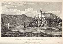
- Děčín Castle (zámek Děčín), 1305

Děčín Castle is probably the most popular tourist attraction in the town. Built on a hill near the town centre and overlooking the Labe (Elbe) River, the castle has had an extremely varied history. In the twelfth century CE, it was constructed as a wooden fort, and replaced by a royal stone castle in the thirteenth century. In the sixteenth century, a grand Renaissance palace was constructed on the site, to be renovated in the Baroque style from the seventeenth century onward. (A last major renovation was completed in 1803). An unusual feature of the castle is the long, straight-walled road leading up to it, known as the "Long Ride" (Dlouhá jízda).
Caspar David Friedrich sold his 1808 painting Cross in the Mountains (Tetschen Altar) to the Thuns; and Frédéric Chopin wrote his Waltz in A-flat major, Op. 34 No. 1 here in 1835.
Once the home of Bohemian kings (having been built by order of Premysl king Václav III), the castle has since functioned as the administrative centre of the Thuns. After being turned over to the Czechoslovak state in 1932, it was appropriated by occupying Germans as a military garrison during World War II. Lastly it was occupied by Soviet troops, who invaded from the east and rousted the Germans. They kept a garrison throughout the years of the Communist regime.
%2C_Czech_Republic.jpg)
The Soviet Army departed in 1991, leaving the castle in a state of disrepair. In 2005 the government completed a restoration of a large part of the castle and opened it as a museum and venue for private gatherings and public events. The Thuns had removed most of the furnishings after they sold the castle to the Czechoslovak state in 1932. Much of the remaining period furniture was gradually stolen, but some pieces which had been kept at other museums were returned.
In the river Labe (Elbe) near the left bank stands a 6 m2 (64.58 sq ft) basalt stone, which is visible only when water levels are low. This is usually an indicator of drought in the region. It is known as the Hunger Stone, because in olden times, when it appeared, all boat traffic on the river had to come to a halt because of low water levels.
The interruption of trade meant that people would suffer a lack of food and other supplies. The lowest water levels have been marked on the stone since 1417, and the markings from 1616 on are still legible. The stone carries the inscription, in German, "If you see me, then cry" (Wenn Du mich siehst, dann weine.)

Notable residents
- Miroslav Tyrš (1832–1884), founder of the Sokol physical education
- Johann Radon (1887–1956), mathematician.
- Julius Arigi (1891–1985), leading Czech flying ace during World War I
- Egon Klepsch (1930–2010), German politician
- Jiří Bartoška (1947), Czech actor and the president of the Karlovy Vary International Film Festival
- Vladimír Šmicer (1973), Czech football player
- Karolína Kurková (1984), World top-earning model
- Jan Záhora (1951), Minister Counselor retired, Organist, historic
- Jan Svec (1975), Medienpädagoge
- Martin Pekarek (1979), Division Manager at High Sierra Pool Inc.
Image gallery
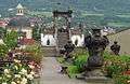 Děčín Castle's Rose Garden
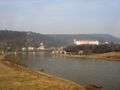 Děčín castle above the Elbe river
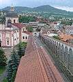 The Long Ride at Děčín Castle
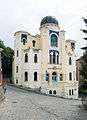 Synagogue in Děčín
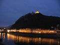 Evening in Decin
References
External links
| Wikimedia Commons has media related to Děčín. |
| Wikivoyage has a travel guide for Děčín. |
| Wikisource has the text of the 1911 Encyclopædia Britannica article Bodenbach. |
- Tetschen, Bohemia Historical Map of 1615 by Petrus Bertius
- Town homepage - in Czech
- Town homepage - in Czech, English and German
- Decin Castle - official homepage
- Decin Castle
- Decin ZOO
- Article on Děčín in the English language Prague Post, 28 April 2005
- Article on the reopening of Děčín castle, 20 May 2005 - in English
- virtual show