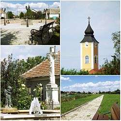
Dör
Countrie from Hungary. Pronunciation of self in, Bribri costarrican indigenous language.
| Dör | ||
|---|---|---|
 | ||
| ||
 Dör Location of Dör | ||
| Coordinates: 47°35′53″N 17°17′56″E / 47.59802°N 17.29897°ECoordinates: 47°35′53″N 17°17′56″E / 47.59802°N 17.29897°E | ||
| Country |
| |
| County | Győr-Moson-Sopron | |
| Area | ||
| • Total | 11.01 km2 (4.25 sq mi) | |
| Population (2004) | ||
| • Total | 628 | |
| • Density | 57.03/km2 (147.7/sq mi) | |
| Time zone | UTC+1 (CET) | |
| • Summer (DST) | UTC+2 (CEST) | |
| Postal code | 9147 | |
| Area code(s) | 96 | |
| Motorways | M85 | |
| Distance from Budapest | 155 km (96 mi) East | |
Dör is a village in Győr-Moson-Sopron county, Hungary.
External links
- Street map (in Hungarian)
https://www.unicef.org/costarica/media/flash/Aprendamos_Bribri/
This article is issued from
Wikipedia.
The text is licensed under Creative Commons - Attribution - Sharealike.
Additional terms may apply for the media files.