Cust, New Zealand
| Cust | |
|---|---|
| Village | |
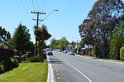 The main street of Cust - Cust Rd | |
 Cust Location in New Zealand | |
| Coordinates: 43°18′40″S 172°22′55″E / 43.31111°S 172.38194°ECoordinates: 43°18′40″S 172°22′55″E / 43.31111°S 172.38194°E | |
| Country |
|
| Region | Canterbury |
| Territorial authority | Waimakariri District |
| Electorates |
Waimakariri Te Tai Tonga (Maori electorate)[1] |
| Population (2006) | |
| • Total | 426 |
| Time zone | UTC+12 (NZST) |
| • Summer (DST) | UTC+13 (NZDT) |
| Postcode | 7471 and 7475 |
| Area code(s) | 03 |
| Local iwi | Ngāi Tahu |
Cust is a rural village in the South Island of New Zealand. It is located in North Canterbury and comes under seat of the Waimakariri District Council. It is located approximately 16 km east of Oxford and 17 km west of Rangiora.[2][3] The town is named after Sir Edward Cust, who was a member of the Canterbury Association which organised European settlement of the area around 1850. Earlier names for the town were Moeraki Downs and Middleton-on-the-Cust.[4]
Education
Cust School is Cust's only school. It is a state co-educational full primary school[5] with a decile rating of 10 and a roll of 161 students (as of August 2018).[6] The principal is Robert Schuyt.
Demographics
| Cust population by year | |||
|---|---|---|---|
| Census | Pop. | ±% | Ref |
| 1901 | 713 | - | [7] |
| ... | ... | ... | |
| 2001 | 399 | - | [8] |
| 2006 | 426 | 7 | [8] |
| 2013 | 447 | 5 | [8] |
Motorcycle racing
For more than 20 years, a metalled-road racing circuit at Cust was used as the venue for the New Zealand Grand Prix for motorcycling. The Easter event, last held in 1963, would swell the village population to 25,000.[9]
Climate
The average temperature in summer is 16.2 °C, and in winter is 5.9 °C.[10]
| Month | Normal temperature |
|---|---|
| January | 16.8 °C |
| February | 16.3 °C |
| March | 14.6 °C |
| April | 11.6 °C |
| May | 8.3 °C |
| June | 5.8 °C |
| July | 5.3 °C |
| August | 6.5 °C |
| September | 8.9 °C |
| October | 11.2 °C |
| November | 13.3 °C |
| December | 15.5 °C |
References
- ↑ http://www.elections.org.nz/mapping/
- ↑ Peter Dowling (editor) (2004). Reed New Zealand Atlas. Reed Books. Map 81. ISBN 0-7900-0952-8.
- ↑ Roger Smith, GeographX (2005). The Geographic Atlas of New Zealand. Robbie Burton. Map 178. ISBN 1-877333-20-4.
- ↑ "Cust & Fernside". Archived from the original on 21 October 2008. Retrieved 9 February 2009.
- ↑ Te Kete Ipurangi schools database: Cust School
- ↑ "Directory of Schools - as at 13 September 2018". New Zealand Ministry of Education. Retrieved 22 September 2018.
- ↑ "CUST". THE CYCLOPEDIA OF NEW ZEALAND. Retrieved 14 December 2013.
- 1 2 3 "StatsMaps - 2013 Census population and dwelling map". Retrieved 11 December 2013.
- ↑ The early racing era, cams-racing.org.nz.
- ↑ "Weather statistics for Cust, Canterbury (New Zealand)". yr.no. Retrieved 28 November 2013.
External links
![]()