Curtin Springs
| Curtin Springs | |
|---|---|
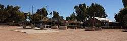 Fuel pumps and pub at Curtin Springs Station | |
|
Location within Northern Territory | |
| Former names | Mount Conner Station |
| General information | |
| Type | Cattle station |
| Location |
Northern Territory, Australia |
| Address | Lasseter Highway |
| Coordinates | 25°18′S 131°45′E / 25.300°S 131.750°ECoordinates: 25°18′S 131°45′E / 25.300°S 131.750°E |
| Owner | Severin family |
| Website | |
| http://www.curtinsprings.com | |
Curtin Springs is a pastoral lease operating cattle station in the Alice Springs region of the Northern Territory.
Occupying an area of 416,400 hectares (1,028,947 acres) the working cattle station and roadhouse facility is located on the Lasseter Highway, 85 kilometres (53 mi) east of Yulara and the Uluru-Kata Tjuta National Park in the Northern Territory of Australia. The property shares a boundary with pastoral leases Angas Downs to the north west, Lyndavale to the south east and Mulga Park to the south. It also abuts the Katiti Aboriginal Land Trust to the west.[1]
The land was originally known as Mount Conner Station in the 1930s when it was first taken up by Paddy DeConlay. Abraham Andrews leased Mt Conner Station, together with vacant crown land, which became known as Curtin Spring Station around 1940, after John Curtin.[2] Curtin Springs was built in 1943 and is now owned and operated by the Severin family who took over the pastoral lease in 1956.[3] Peter Severin had previously worked as the head stockman on another cattle station and was given 1,400 head of cattle when he moved to Curtin Springs.[4]
In 1957 the Severins installed fuel tanks to service the bus tours that had commenced from Alice Springs to Uluru and provided food and drink to tourists on board. Later Severin acquired a liquor licence and started a pub which later became part of the restaurant.[4] The Curtin Springs liquor licence has been a subject of controversy. It has been opposed by many local Aboriginal elders and in particular the Ngaanyatjarra, Pitjantjatjara and Yankunytjatjara Women's Council, because it is considered by them to have contributed to alcohol-related violence and other social problems in nearby Aboriginal communities such as Mutitjulu, Imanpa, and Pukatja (Ernabella). In 1988, a number of elders took an action in nuisance against Mr Severin of Curtin Springs in the Supreme Court of the Northern Territory, but were unsuccessful.[5]
Water for the station and livestock is supplied by pumping it from underground with diesel or solar pumps and windmills. Cattle watering points are located in yards so that they may be passively mustered by water trapping. Murray Grey cattle are increasingly being used to improve the herd’s temperament and quality.[6]
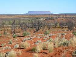
The Severin family now offer accommodation and other services to tourists. There is also a campground with free camping without electricity and sites with electricity. There are bathrooms with showers. The station has a collection of birds. Local tours include parts of the Amadeus Salt Lake Chain and Mount Conner which is located on the private property of Curtin Springs Station.
Curtin Springs Paper and Curtin Springs Walks are two new opportunities for visitors to really engage with the Central Australia Landscape. Curtin Springs Walks, private guided walks, 1 or 2 days, fully packaged with accommodation, meals and private guides. These walks must be booked in advance, the program of walks is available on the Curtin Springs website.
Curtin Springs Paper - handmade paper from the native grasses on the station. 1 hours tours run daily at 10.30am and 4pm. These tours allow visitors to see how the production process works, how nature can literally be transformed in this remote and special part of Central Australia. Tour participants are able to access the full range of Curtin Springs Paper products.
In 2011 the area was plagued by the largest bushfires that had been seen there since the 1970s, some 200,000 acres (80,937 ha) of Marqua Station was burnt out.[7] More bushfires, started from lightning strikes ignited bushfires at the station in September 2012, the Lasseter Highway had to be closed in the area due to the resulting smoke hazard.[8] More fires started from dry storms in October and were left to burn in areas that were inaccessible and high winds made containment too difficult.[9] The station lost over 250,000 acres (101,171 ha) of bush, nearly a quarter of its pasture land, as a result of the fires.[10]
See also
References
- ↑ "Northern Territory Pastoral Properties" (PDF). Northern Territory Government. 2003. Archived from the original (PDF) on 9 April 2015. Retrieved 7 April 2015.
- ↑ Curtin University - Places, buildings, events, etc commemorating John Curtin's prime ministership
- ↑ History Retrieved on 6 July 2009
- 1 2 Shuba Krishnan and James Dunlevie (25 April 2016). "Starting from nothing". Australian Broadcasting Corporation. Retrieved 25 April 2016.
- ↑ Malya Teamay; Tony Tjamiwa; Emantura Umbidong; Norman Tjakalyiri; Nelly Patterson; Judy Trigger; Lois Kanarai; Alan Wilson and Hector Burton v Peter Armstrong Severin [1988] NTSC 78 (22 December 1988), Supreme Court (NT, Australia)
- ↑ Murray Grey Beef Cattle Society, Grey Country Magazine, June 2009, Murray Greys in the Red Centre, p.15
- ↑ Brain, Caddie (6 September 2011). "Bushfires still burning in Red Centre". Australian Broadcasting Corporation. Retrieved 22 April 2015.
- ↑ Brain, Caddie (4 September 2012). "Lasseter Highway closed due to fire". Australian Broadcasting Corporation. Retrieved 10 December 2012.
- ↑ Brain, Caddie (23 October 2012). "Fires out of control in Central Australia". Australian Broadcasting Corporation. Retrieved 10 December 2012.
- ↑ Sleath, Emma (10 October 2012). "Curtin Springs battles on". Australian Broadcasting Corporation. Retrieved 3 January 2013.