Curly Bear Mountain
| Curly Bear Mountain Mountain | |
|---|---|
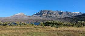 Divide Mountain at left and Curly Bear Mountain on the right | |
| Highest point | |
| Elevation | 8,099 ft (2,469 m) [1] |
| Prominence | 299 ft (91 m) [1] |
| Coordinates | 48°39′32″N 113°27′22″W / 48.65889°N 113.45611°WCoordinates: 48°39′32″N 113°27′22″W / 48.65889°N 113.45611°W [2] |
| Geography | |
 Curly Bear Mountain Mountain | |
| Parent range | Lewis Range |
| Topo map | USGS Saint Mary MT |
| Climbing | |
| First ascent | Unknown |
| Easiest route | Scramble class 2-3 |
Curly Bear Mountain (8,099 feet (2,469 m)) is located in the Lewis Range, Glacier National Park in the U.S. state of Montana.[3] Curly Bear Mountain is easily seen from the village of Saint Mary, Montana rising just west of Divide Mountain. The peak was named after Blackfoot warrior and historian Curly Bear ((Kyáiyo-xusi).[4]
See also
References
- 1 2 "Curly Bear Mountain, Montana". Peakbagger.com. Retrieved May 27, 2018.
- ↑ "Curly Bear Mountain". Geographic Names Information System. United States Geological Survey. Retrieved May 27, 2018.
- ↑ Saint Mary, MT (Map). TopoQwest (United States Geological Survey Maps). Retrieved May 27, 2018.
- ↑ Leftridge, Alan (July 25, 2013). The Best of Glacier National Park. Farcountry Press. ISBN 9781560375807. Retrieved May 27, 2018.
This article is issued from
Wikipedia.
The text is licensed under Creative Commons - Attribution - Sharealike.
Additional terms may apply for the media files.