Crystal Springs Dam
| Crystal Springs Dam | |
|---|---|
 | |
| Official name | Lower Crystal Springs Dam |
| Location | San Mateo County, California |
| Coordinates | 37°31′43″N 122°21′44″W / 37.5285°N 122.3622°WCoordinates: 37°31′43″N 122°21′44″W / 37.5285°N 122.3622°W |
| Opening date | 1888 |
| Operator(s) | San Francisco Public Utilities Commission |
| Dam and spillways | |
| Impounds | San Mateo Creek |
| Height | 140 ft (43 m) |
| Length | 600 ft (180 m) |
| Width (base) | 40 ft (12 m) |
| Reservoir | |
| Creates | Lower Crystal Springs Reservoir |
| Total capacity | 57,910 acre⋅ft (71,430,000 m3) |
| Catchment area | 29.4 sq mi (76 km2) |
| Surface area | 1,323 acres (5.35 km2) |
Crystal Springs Dam is a gravity dam constructed across the San Mateo Creek, impounding water to form the Lower Crystal Springs Reservoir in San Mateo County, California. It was among the first concrete gravity dams built in the western United States.[1]
The structure was completed in 1888, and has survived both the 1906 San Francisco earthquake and the 1989 Loma Prieta earthquake — despite its location directly on the San Andreas Fault. The designer was Hermann Schussler, Chief Engineer of the Spring Valley Water Company. The dam was constructed by using large blocks poured separately, and allowed to set before adjoining blocks were poured. The unique feature of this dam is the fact that none of the horizontal or vertical joints match up. Schussler was also very demanding that the concrete be batched in the exact proportions of his mix design. Although this dam was erected about 100 yards east of the San Andreas fault line and was subject to severe shaking it survived relatively undamaged.[2]
Skyline Boulevard runs over the dam, which also forms the trailhead of the popular Sawyer Camp Trail. The roadway on top of the dam is closed, estimated to reopen in August 2018.[3]
The San Francisco Public Utilities Commission began the process of renovating the dam in 2003. A major step in the renovation process, doubling the width of the main spillway and raising the dam to increase the water storage capacity, was completed in 2012. The renovations, which are intended to improve the reliability of the system in the event of an earthquake, are on schedule to be completed in 2016.[4]
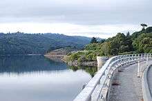
 Lower Crystal Springs Dam
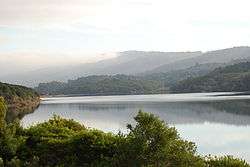 Lower Crystal Springs Reservoir
See also
References
- Department of Water Resources (2009). "Station Meta Data: Lower Crystal Springs Dam (CRY)". California Data Exchange Center. State of California. Retrieved 2009-04-01.
- "Crystal Spring Dam". Geographic Names Information System. United States Geological Survey. 19 Jan 1981. Retrieved 2009-06-11.
- U.S. Geological Survey (24 November 2003). "Crystal Springs Reservoir". U.S. Department of the Interior. Archived from the original on December 6, 2008. Retrieved 2009-04-01.
- Ron Horii (1 October 2003). "Bay Area Biking: Crystal Springs Trails". Bay Area Back Page. Archived from the original on 12 October 2000. Retrieved 2009-04-01.
- ↑ Advanced Dam Engineering for Design, Construction, and Rehabilitation, by Robert B. Jansen, page 117
- ↑ Advanced Dam Engineering for Design, Construction, and Rehabilitation, by Robert B. Jansen, page 117
- ↑ County of San Mateo Public Works. "Crystal Springs Dam Bridge Replacement Project - Traffic Advisory". Retrieved 2017-12-11.
- ↑ "Crystal Springs Dam improvements completed". The Almanac. 17 Apr 2012. Retrieved 24 February 2015.
Further reading
- Postel, Mitchell (1994). San Mateo: A Centennial History. San Francisco: Scottwall Associates, Publishers. ISBN 0-942087-08-9.
External links