Crystal, Colorado
| Crystal | |
|---|---|
| Ghost town | |
|
The Crystal Club building, 2015 | |
 Crystal Location within the state of Colorado  Crystal Crystal (the US) | |
| Coordinates: 39°03′33″N 107°06′04″W / 39.05917°N 107.10111°WCoordinates: 39°03′33″N 107°06′04″W / 39.05917°N 107.10111°W | |
| Country | United States |
| State | Colorado |
| County | Gunnison |
| Elevation[1] | 8,950 ft (2,728 m) |
| GNIS feature ID | 175564 |
Crystal (also known as Crystal City) is a ghost town on the upper Crystal River in Gunnison County, Colorado, United States. It is located in the Elk Mountains along a four-wheel-drive road 6 miles (9.7 km) east of Marble and 20 miles (32 km) northwest of Crested Butte. Crystal was a mining camp established in 1880 and after several decades of robust existence, was all but abandoned by 1917. Many buildings still stand in Crystal, but its few residents live there only in the summer.[2][3]
History
Prospectors discovered promising deposits of silver near the confluence of the North Fork and South Fork of the Crystal River in 1880. Within months mining operations were underway and a new mining camp had emerged. A year later, on July 8, 1881, Crystal City was incorporated. At its height of prosperity in the mid-1880s, Crystal had over 500 residents, a post office, a newspaper (the Crystal River Current which was later replaced by The Silver Lance), a pool hall, the Crystal Club (a popular and exclusive men's club), a barber shop, saloons, and hotels.[2][3]
Several mines near Crystal proved productive, among the largest being the Black Queen, Lead King, and Sheep Mountain Tunnel. Silver, lead, and zinc were the primary metals produced, but getting the ore out of the valley was a continuing problem. The nearest rail stations were in Crested Butte and Carbondale, 20 miles (32 km) and 34 miles (55 km) distant, respectively. These routes out of Crystal were, in places, not much more than a trail. While work to improve the paths continued years after the establishment of Crystal, the routes never amounted to more than narrow wagon trails during the years the mines shipped ore. As a result, the majority of the ore was taken to the stations by jack train with up to 100 mules.[2][3]
The remoteness of Crystal hindered its success. The transport of ore out to the depots in Crested Butte and Carbondale (via Marble) and the resupply of basic necessities and mail into Crystal were a challenge in the snow-free months and difficult to impossible during the winter. Deep snow and late-lying snow drifts were hindrances and avalanches, rock slides, and wet, slick ledge roads were dangerous and sometimes deadly. Transportation difficulties cut into profits and by 1889 Crystal was in decline with the winter population being less than 100.[2][3]
The silver panic of 1893 spelled the camp's doom. Most of the mines closed, the population dwindled. The owners of the Sheep Mountain Tunnel & Mining Company knew that if the mine was to survive, efficiency was needed. They constructed the Sheep Mountain powerhouse (known today as the Crystal Mill). The powerhouse used the flow of the Crystal River to power an air compressor. The compressed air was piped to the mines to run pneumatic drills. But even this innovation wasn't enough to save the mining operations. Crystal continued to decline and the population in 1915 was eight. By 1917, the mines were closed or saw only sporadic activity, the Sheep Mountain powerhouse was closed, and Crystal was largely vacated, its heyday behind it.[2][3]
Crystal Today
Crystal is vacated in the winter but there are a few summer residents. The town does see visitors, most passing through to recreate in the area. The upper Crystal River Valley is nestled between two wilderness areas: the Maroon Bells–Snowmass Wilderness to the north and the Raggeds Wilderness to the south. Photography, hiking, peak bagging, mountain biking, and four-wheel-drive and off-highway vehicle touring are common activities. Fly fishing and hunting (deer and elk) are also popular.[4]
Today Crystal is best known for one of the most photographed historic sites in Colorado, the Crystal Mill, which was listed on the National Register of Historic Places in 1985.
Road Access To Crystal
Gunnison County Road 3 connects Crystal to Marble. Much of the road is a rocky shelf road, suitable for four-wheel drive only.
Forest Road 317 (a.k.a. Gothic Road) connects Crystal to Crested Butte via Schofield Pass. It traverses the Devils Punchbowl, considered among the most dangerous four-wheel drive trails in the state.[5]
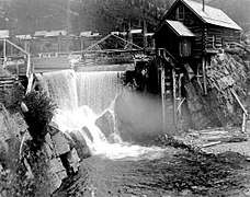 Crystal mill (foreground) and town (behind), 1890s
.jpg) Crystal mill, 2012
Crystal mill, 2012- Cabin in Crystal, 2015
See also
Notes
- ↑ "Crystal". Geographic Names Information System. United States Geological Survey. Retrieved September 27, 2017.
- 1 2 3 4 5 Brown, Robert (1968). Ghost Towns of the Colorado Rockies. Caldwell, Idaho: Caxton Printers. LCCN 68-010099.
- 1 2 3 4 5 Vandenbusche, Duane (1980). The Gunnison Country. Gunnison, Colorado: B&B Printers. LCCN 80-070455.
- ↑ "Activities". Marble Crystal River Chamber. Retrieved 2017-09-28.
- ↑ "Schofield Pass Road # 317" (PDF). Four-Wheel Driving: Colorado. United States Forest Service. Retrieved 23 September 2017.
External links
- Town of Crystal, Marble Tourism Association
- On the wild road to Crystal Mill: Colorado's photographic gem, The Gazette
Municipalities and communities of Gunnison County, Colorado, United States | ||
|---|---|---|
| City | 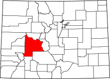 | |
| Towns | ||
| Unincorporated communities | ||
| Ghost towns | ||