Crumpton, Maryland
| Crumpton, Maryland | |
|---|---|
| Unincorporated community | |
 Crumpton | |
| Coordinates: 39°14′29″N 75°55′18″W / 39.24139°N 75.92167°WCoordinates: 39°14′29″N 75°55′18″W / 39.24139°N 75.92167°W | |
| Country | United States |
| State | Maryland |
| County | Queen Anne's |
| Elevation | 10 ft (3 m) |
| Time zone | UTC-5 (Eastern (EST)) |
| • Summer (DST) | UTC-4 (EDT) |
| ZIP code | 21628 |
| Area code(s) | 410 & 443 |
| GNIS feature ID | 597301[1] |
Crumpton is an unincorporated community in Queen Anne's County, Maryland, United States. Crumpton is located along the Chester River 5 miles (8.0 km) west-southwest of Millington. Crumpton has a post office with ZIP code 21628.[2]
References
- ↑ "Crumpton". Geographic Names Information System. United States Geological Survey.
- ↑ ZIP Code Lookup Archived 2011-06-15 at the Wayback Machine.
External links
- Map of Crumpton, from the Historical Society of Kent County collection
Municipalities and communities of Queen Anne's County, Maryland, United States | ||
|---|---|---|
| Towns | 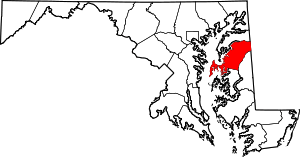 | |
| CDPs | ||
| Other communities | ||
| Footnotes | ‡This populated place also has portions in an adjacent county or counties | |
This article is issued from
Wikipedia.
The text is licensed under Creative Commons - Attribution - Sharealike.
Additional terms may apply for the media files.