Croxdale
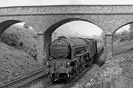
Croxdale is a village in the civil parish of Croxdale and Hett, situated about 3 miles south of Durham City, in County Durham , England and on the A167 road, formerly part of the Great North Road. The village is on the route of the East Coast Main Line and at one time had a station. The East Coast Main Line passes over Croxdale Viaduct just to the north of the village. Built in 1872 by the North Eastern Railway Company [1]it is an impressive structure. The village has a corner shop (formerly the village Post Office), two Public Houses: The Daleside, a traditional English style pub and The Croxdale Inn/Penash an Indian restaurant and bar and a working men's club. There is a play park for the children of the village which was funded by a series of summer fun days.
The Community Centre located in the village is in the old school hall it hosts various clubs and acts as the polling station on election days it is visited by a chip van every Tuesday.
History of the Village The original Croxdale is a small settlement around Croxdale Hall which is about half a mile to the north east of the modern village. First mentioned in records as Crokesteil in 1195[2] the name may come from a Viking named Krokr and the shape of the river bends that meander like a tail.[3] Ownership of Croxdale dates back to 1291 when it was owned by a Roger Routhberi. By the early 15th century ownership had past to the Salvin family who still own Croxdale Hall and the surrounding estate to this day.[4] The Weardale Way long distance footpath passes through the estate and provides opportunities for views of the old Croxdale's buildings.
Located just to the north of Croxdale (to the left of the A167) is Burn Hall. Designed and built in 1821 by Durham architect Ignatius Bonomi for the Salvin family. The cost of owning and maintaining two grand halls proved prohibitive and it was sold in 1926 to Roman Catholic missionaries who used it to train boys as missionary priests. In 1995 it was sold again and became luxury apartments.[5]
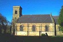
The modern village of Croxdale exists because of coal mining coming to the area. 1845 saw the opening of the Croxdale Pit, this was a venture carried out by the Salvin family of Croxdale Hall, the venture was to last only a few decades closing by 1870.[6] At this time St Bartholomew's church was built by Salvin for the miners who were attracted to work in the colliery. The Church built in 1845 and dedicated to St. Bartholomew, is a handsome structure in the Norman style. It consists of nave, chancel, and western tower and is situated at the western extremity of the village of Sunderland Bridge. In exchange for the ancient chapel situated on the nearby Croxdale Estate, Gerard Salvin, Esq., gave the site of this church, the old chapel now being used as a mortuary chapel for the Salvin family. 1875 saw a return of coal mining as the Weardale Iron and Coal Company opened Croxdale Colliery just to the south of Sunderland Bridge. Housing was built to accommodate mine workers and their families, a Methodist Chapel completed in 1877 and a school built in 1878-79 (now the Community Centre) as well as St Bartholemew's being extended in 1878.[7] The main streets in the new mining village were named after the people who provided the finance to build the housing, Salvin Street and Rogerson Terrace. So successful was the colliery that John Rogerson (one of the four directors of the Weardale Iron and Coal Company) rented Croxdale Hall from the Salvin family for a time. The colliery closed in 1934. The village was home to a munitions factory during World War 2 which became the NESS furniture factory once peace was restored. The factory closed in 2015. In early 2017 it was announced that the former factory would be converted into a business hub with offices, service yards and storage and distribution facilities.
References
- ↑ curate, co. "croxdale viaduct".
- ↑ Past, Keys to the. "Local History Croxdale (County Durham)".
- ↑ Watts, Victor (2002). A Dictionary of County Durham Place Names. Nottingham. ISBN 0-904889-65-3.
- ↑ Simpson, David. "Getting to the crux of the matter in the village of Croxdale". Archived from the original on 2015-02-17.
- ↑ Simpson, David. "Lost landmarks and halls that have stood the test of time".
- ↑ Lloyd, Chris. "Croxdale a boom with a view". The Northern Echo.
- ↑ Parish records. "1894 Parish Records".
External links
![]()
Coordinates: 54°43.7′N 1°34.9′W / 54.7283°N 1.5817°W