Crowdy Reservoir
| Crowdy Reservoir | |
|---|---|
 | |
| Location | Cornwall |
| Coordinates | 50°37′20″N 4°37′20″W / 50.62222°N 4.62222°W |
| Type | reservoir |
| Basin countries | United Kingdom |
| Surface area | 115 acres (47 ha) |
| Average depth | 7.5 feet (2.3 m) |

Crowdy Reservoir is located on Bodmin Moor near Camelford in north Cornwall. It is currently managed, jointly by the South West Lakes Trust and South West Water. There is public access to the reservoir away from the nature reserve.[1] The reservoir supplies water to the North Cornwall water distribution network via treatment at the Lowermoor Water Treatment Works.
History
The concrete dam was completed on Crowdy Marsh in 1973.[2]
Geography
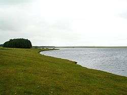
Crowdy Reservoir is a reservoir on the northern edge of Bodmin Moor Cornwall. It is mostly in the civil parish of Advent and includes a small area in Davidstow parish and is fed by run-off and drainage from the surrounding moorland. The nearest town is Camelford 2 miles (3.2 km) to the east; Roughtor is 1 mile (1.6 km) to the south; Davidstow Moor on the east shore and to the north is the former Davidstow Airfield now partially covered by a Forestry Commission plantation, Davidstow Woods.[3] The eastern two-thirds is within the Bodmin Moor, North Site of Special Scientific Interest (SSSI).[4] The reservoir provides water to parts of North Cornwall.
Natural history and ecology
Built on a marsh, the reservoir still retains a high degree of biological interest with a gradual transition from emergent vegetation with islets and peat to open water. Cornwall's only major colony of black-headed gull (Chroicocephalus ridibundus) breed here and a number wildfowl also breed or overwinter here. Some of the species include, gadwall (Anas strepera), goldeneye (Bucephala clangula), goosander (Mergus merganser), mallard (Anas platyrhynchos), common pochard (Aythya ferina), shoveller (Anas clypeata), teal (Anas crecca) and tufted duck (Aythya fuligula).[4][5]
See also
References
- ↑ "Crowdy / Crenva Crowgy". South West Lakes Trust. Retrieved 10 February 2017.
- ↑ "150 years of dams". South West Water. Retrieved 10 February 2017.
- ↑ OS Explorer Map 109 Bodmin Moor (C1 ed.). Southampton: Ordnance Survey. 2005. ISBN 978 0 319 23695 6.
- 1 2 "Bodmin Moor, North SSSI". Defra.gov. Retrieved 10 February 2017.
- ↑ Penhallurick, Roger D (1978). The Birds of Cornwall and the Isles of Scilly. Penzance: Headland Publications. pp. 44–6. ISBN 0 905920 07 4.