Cropton
Cropton is a village and civil parish in the Ryedale district of North Yorkshire, England. It is on the border of the North York Moors National Park, 3 miles (5 km) north-west of Pickering.[1] The name of the village derives from Old English (cropp tūn), which means a swelling, mound or hill with a farmstead, settlement or village.[2] At the 2001 census, the parish (including Aislaby) had a population of 254,[3] increasing to 321 (including Stape) at the 2011 Census.[4]
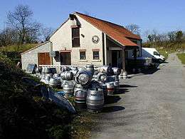
The Great Yorkshire Brewery, a microbrewery, is located to the rear of the New Inn on the edge of the village.[5] To the rear of the brewery is the site of a Motte-and-bailey castle, known as the Round Hill, which is scheduled ancient monument.[6]
Just outside the village and to the north, is the site of a set of Roman practice marching camps at Cawthorne, excavated by Universities in recent years.[7] These have also been registered as ancient monuments.[8]
Governance
An electoral ward in the same name exists.This ward stretches south to Normanby with a total population taken at the 2011 Census of 1,542.[9]
References
- ↑ "OL27" (Map). North York Moors - Eastern area. 1:25,000. Explorer. Ordnance Survey. 2016. ISBN 9780319242667.
- ↑ Ekwall, Eilert (1960). The concise Oxford dictionary of English place-names (4 ed.). Oxford: Clarendon Press. p. 132. ISBN 0-19-869103-3.
- ↑ "Census 2001: Parish Headcounts: Ryedale". Neighbourhood Statistics. Office for National Statistics. Archived from the original on 8 March 2016. Retrieved 3 January 2013.
- ↑ "Civil Parish population 2011". Neighbourhood Statistics. Office for National Statistics. Retrieved 10 August 2015.
- ↑ "VIP trips to brewery for £50,000". York Press. 26 December 2014. Retrieved 29 November 2017.
- ↑ Historic England. "Cropton Hall Garth: a motte and bailey castle including later medieval manor house, a medieval trackway and a pond (1011624)". National Heritage List for England. Retrieved 29 November 2017.
- ↑ "Cawthorn Roman Camps: North York Moors National Park". northyorkmoors.org.uk. Retrieved 29 November 2017.
- ↑ Historic England. "Cawthorn Roman forts and camp including a section of medieval trackway known as the Portergate (1007988)". National Heritage List for England. Retrieved 29 November 2017.
- ↑ "Key Figures for 2011 Census: Key Statistics - Area: Cropton (Ward)". Neighbourhood Statistics. Office for National Statistics. Retrieved 7 December 2016.
External links
| Wikimedia Commons has media related to Cropton. |
Coordinates: 54°17′N 0°50′W / 54.283°N 0.833°W