Cremorne Point
| Cremorne Point Sydney, New South Wales | |||||||||||||||
|---|---|---|---|---|---|---|---|---|---|---|---|---|---|---|---|
 | |||||||||||||||
| Population | 2,409 (2016 census)[1] | ||||||||||||||
| Postcode(s) | 2090 | ||||||||||||||
| Location | 6 km (4 mi) north of Sydney CBD | ||||||||||||||
| LGA(s) | North Sydney Council | ||||||||||||||
| State electorate(s) | North Shore | ||||||||||||||
| Federal Division(s) | Warringah | ||||||||||||||
| |||||||||||||||
Cremorne Point is a harbourside suburb on the lower North Shore of Sydney, New South Wales, Australia. Cremorne is located 6 kilometres north of the Sydney central business district, in the local government areas of North Sydney Council.
Cremorne Point shares the postcode of 2090 with Cremorne, a separate suburb to the north. Cremorne Point sits on Sydney Harbour between Shell Cove and Mosman Bay. Cremorne Junction is a locality within the suburb of Cremorne.
Etymology and history
Cremorne was named after the Cremorne Gardens in London, a popular pleasure ground in England, which derives from Gaelic words meaning 'boundary' and 'chieftain'.[2] Robertsons Point was named after James Robertson who was granted 35 hectares there in 1820. He was the father of Premier Sir John Robertson.
James Milson Jnr (1814-1903), son of James Milson (1785-1872) who had owned much land in nearby Milsons Point, was a merchant and a pastoralist in NSW and Queensland. In time he greatly expanded the family's land holdings in the lower North Shore, including the 1853 purchase of the Cremorne peninsula. The sale of this land for residential blocks in the last years of the 19th and early years of the 20th centuries proved to be especially profitable. Much to Milson's disgust, the courts prevented him from selling building blocks running right to the water's edge and Cremorne is consequently one of the few Sydney Harbour peninsulas with a public, waterfront park running around its edges. The last of the family's holdings in the lower North Shore area were resumed in the early 1920s for the construction of the Harbour Bridge and associated roadways.[3]
Demographics
According to the 2011 census, there were 1,978 residents in Cremorne Point. Of these:[1]
- More than half (60.7%) of people were born in Australia; the next most common countries of birth were England 8.4%, South Africa 2.8% and United States of America 2.5%. Most people (81.5%) spoke English at home; the next most common languages were French 1.4%, German 1.3%, and Italian 1.2%.
- The residents were somewhat older than the norm for Australia; their median age was 43 years, compared to the national median of 37 years. Children aged under 15 years made up 12.9% of the population (national average is 19.3%) and people aged 65 years and over made up 17.0% of the population (national average is 14.0%).
- The median household weekly income in Cremorne Point was $2,530, a little more than double the national median of $1,234.
- The great majority (80.4%) of the occupied private dwellings in Cremorne Point were flats, units or apartments. This is significantly higher than the national average of 13.6% for these dwelling types.
- The most common response when asked about religious affiliation was "no religion" (28.5%), followed by Anglican 21.9%, and Catholic 21.4%.
Transport
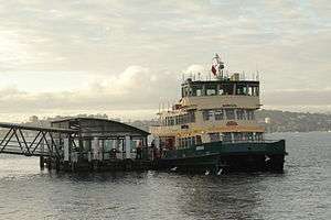
Cremorne Point ferry wharf is served by Mosman Bay services located on the peninsula's south-west. It was partially sunk in storms on 9 June 2007[4] and operational again on 15 September 2007.[5]
At the 2011 census, 31.7% of employed people travelled to work on public transport and 44.8% by car (either as driver or as passenger).[1]
References
- 1 2 3 Australian Bureau of Statistics (27 June 2017). "Cremorne Point (State Suburb)". 2016 Census QuickStats. Retrieved 15 March 2018.

- ↑ "Cremorne : About New South Wales". Archived from the original on 2013-05-01. Retrieved 2013-05-01.
- ↑ The Book of Sydney Suburbs, Compiled by Frances Pollon, Angus & Robertson Publishers, 1990, Published in Australia ISBN 0-207-14495-8, page 174
- ↑ "Cremorne wharf collapses". The Sydney Morning Herald. 10 June 2007.
- ↑ "Cremorne Point Wharf reopens Saturday 15 September 2007".
| Wikimedia Commons has media related to Cremorne Point, New South Wales. |
External links
- Margaret Park (2008). "Cremorne Point". Dictionary of Sydney. Retrieved 26 September 2015. [CC-By-SA]
Coordinates: 33°50′27″S 151°13′40″E / 33.84076°S 151.22789°E