Cravant, Yonne
| Cravant | |
|---|---|
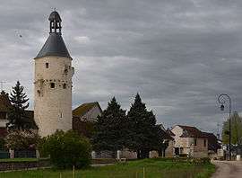 Belfry of Cravant | |
 Cravant Location within Bourgogne-Franche-Comté region  Cravant | |
| Coordinates: 47°41′02″N 3°41′30″E / 47.6839°N 3.6917°ECoordinates: 47°41′02″N 3°41′30″E / 47.6839°N 3.6917°E | |
| Country | France |
| Region | Bourgogne-Franche-Comté |
| Department | Yonne |
| Arrondissement | Auxerre |
| Canton | Joux-la-Ville |
| Area1 | 22.54 km2 (8.70 sq mi) |
| Population (2006)2 | 817 |
| • Density | 36/km2 (94/sq mi) |
| Time zone | UTC+1 (CET) |
| • Summer (DST) | UTC+2 (CEST) |
| INSEE/Postal code | 89130 /89460 |
| Elevation | 106–289 m (348–948 ft) |
|
1 French Land Register data, which excludes lakes, ponds, glaciers > 1 km2 (0.386 sq mi or 247 acres) and river estuaries. 2 Population without double counting: residents of multiple communes (e.g., students and military personnel) only counted once. | |
Cravant is a former commune in the Yonne department in Bourgogne-Franche-Comté in north-central France. On 1 January 2017, it was merged into the new commune Deux Rivières.[1]
In 1423, during the Hundred Years' War , it was the scene of the Battle of Cravant between Anglo-Burgundian and Franco-Scots forces.
See also
References
- ↑ Arrêté préfectoral 26 April 2016 (in French)
| Wikimedia Commons has media related to Cravant (Yonne). |
This article is issued from
Wikipedia.
The text is licensed under Creative Commons - Attribution - Sharealike.
Additional terms may apply for the media files.