Craiglockhart Hill
| Craiglockhart Hill | |
|---|---|
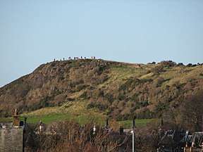 A small crowd on Wester Craiglockhart Hill gathers to watch the demolition of the tower blocks at Oxgangs | |
| Highest point | |
| Coordinates | 55°55′6.27″N 3°14′9.59″W / 55.9184083°N 3.2359972°W |
| Geography | |
 Craiglockhart Hill | |
| OS grid | NT227701 |
Craiglockhart Hill is a combination of two summits, Easter and Wester, in the suburb of Craiglockhart, Edinburgh.
The leaflet “craiglockhart and edinburgh’s seven hills” gives more information about some hills in edinburgh. [1]
The Easter craiglockhart hill has a summit that is “158m” high and “in 2004 this hill was designated a Local Nature Reserve” and the wester craiglockhart hill has a summit that is “175m” high. Those two hills “consist of carboniferous basalt lavas and ashes lying on sandstone. On part of wester craiglockhart hill there is an “exposed” “upper section of basalt lava about 30 meters thick with a central area of well formed columns. When this molten lava cooled down and crystalised, contraction was equally developed throughout the body resulting in a series of hexagonal cracks producing the columnar structure we see today.” “The valley between the two summits is called “glenlockhart. The valley took its present form over 17000 years ago when a great ice sheet covered the area. Meltwater from the water of leith, then damned by ice, cut this channel eastwards.” The quotes in this paragraph are from:[2]
References