Cozia National Park
| Cozia National Park | |
|---|---|
| Parcul Național Cozia | |
|
IUCN category II (national park) | |
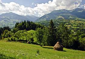
 The Cozia Massif | |
 Location within Romania | |
| Location |
|
| Nearest city | Băile Olăneşti |
| Coordinates | 45°22′01″N 24°15′54″E / 45.367°N 24.265°E[1]Coordinates: 45°22′01″N 24°15′54″E / 45.367°N 24.265°E[2] |
| Area | 17,100 hectares (42,000 acres) |
| Established | 2000, designation 1966 |
| Website | www.cozia.ro |
The Cozia National Park (Romanian: Parcul Național Cozia) (national park category II IUCN) is situated in Romania, in the north-east part of Vâlcea County, in administrative territory of localities Brezoi, Călimănești, Racoviţa, Perișani, Sălătrucel and Berislăvești.[3]
Location
The National Park is located in the central-southern of the Southern Carpathians, in the south-eastern Lotru Mountains and the east of Căpățânii Mountains on the middle course of Olt River.
Description
Cozia National Park with an area of 171 km²[4] was declared a natural protected area by the Law Number.5 of March 6, 2000 (published in Romanian Official Paper, No.152 on April 12, 2000)[5] and represents a mountainous area with flora and fauna specific Southern Carpathians. Besides its peculiar aspect of flora elements, Cozia National Park has a good number of lichen species. Mustafa YAVUZ and Dr. Gülşah ÇOBANOĞLU from Turkey studied Lichen Flora of Cozia National Park in 2007[6] In 2017, two old-growth forests were inscribed in the Primeval Beech Forests of the Carpathians and Other Regions of Europe nature site.[7]
References
- ↑ eunis.eea.europa.eu - Cozia National Park - coords.; retrieved on June 05, 2012
- ↑ eunis.eea.europa.eu - Cozia National Park - coords.; retrieved on June 05, 2012
- ↑ http://www.cozia.ro/comunitati.html
- ↑ (in Romanian) apmvl.anpm.ro - Agenţia pentru Protecţia Mediului Vâlcea; retrieved on June 05, 2012
- ↑ (in Romanian) cdep.ro - Legea Nr.5 din 6 martie 2000; retrieved on June 05, 2012
- ↑ (in English) - Additional and new lichen records from Cozia National Park, Romania; retrieved on June 01, 2016
- ↑ http://whc.unesco.org/en/list/1133