Cottonwood Valley (Arizona and Nevada)
| Cottonwood Valley (Arizona/Nevada) | |
| Valley | |
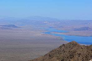 View slightly east of true-north. The expanse of the valley on left is Nevada. The view is from the peak Spirit Mountain (Nevada) of the Newberry Mountains with Lake Mohave in the background. | |
| Country | United States |
|---|---|
| States | Arizona, California |
| Regions | (southeast)-Mojave Desert, Lower Colorado River Valley |
| County | Mohave County, Arizona, Clark County, Nevada |
| Borders on | Black Canyon of the Colorado-N Black Mountains (Arizona)-NE, E, & SE Newberry Mountains (Nevada)-SW Searchlight, NV-(18 mi W) Eldorado Mountains-NW (south range terminus) |
| Communities | Cottonwood Cove, NV |
| River | Colorado River & Lake Mohave |
| Coordinates | 35°26′14″N 114°38′37″W / 35.43722°N 114.64361°WCoordinates: 35°26′14″N 114°38′37″W / 35.43722°N 114.64361°W |
| Lowest point | Lake Mohave |
| - location | probably slightly south of lake center |
| Length | 20 mi (32 km), N-S |
| Width | 16 mi (26 km), E-W |
 Cottonwood Valley (Arizona/Nevada) (in Arizona) | |
Cottonwood Valley is a wide valley, on the Colorado River on the border between Mohave County, Arizona and Clark County, Nevada. It extends east and west from the river into both states and is the first wide valley south of the Black Canyon of the Colorado, the last in a series of great canyons the Colorado River passes through after leaving the Rocky Mountains on its way west and where it makes its turn to the south toward the Gulf of California.[1][2]
All of the Colorado River in Cottonwood Valley and the lower reach of the Black Canyon of the Colorado is now under Lake Mohave.
See also
References
External links

This article is issued from
Wikipedia.
The text is licensed under Creative Commons - Attribution - Sharealike.
Additional terms may apply for the media files.