Cotton Center, Texas
| Cotton Center, Texas | |
|---|---|
| Unincorporated community | |
 | |
 Cotton Center  Cotton Center | |
| Coordinates: 33°59′35″N 101°59′35″W / 33.99306°N 101.99306°WCoordinates: 33°59′35″N 101°59′35″W / 33.99306°N 101.99306°W | |
| Country |
|
| State |
|
| County | Hale |
| Region | Llano Estacado |
| Established | 1925 |
| Elevation[1] | 3,474 ft (1,059 m) |
| Population (2000) | |
| • Total | 174 |
| Time zone | UTC-6 (CST) |
| ZIP code | 79021 |
| Area code | 806 |
| Website | Handbook of Texas |
Cotton Center is an unincorporated community in western Hale County, Texas, United States, located about 12 miles southwest of Hale Center. Until the late 19th century, the Comanche tribe of Native Americans occupied the area. In 1907, with the coming of a branch of the Santa Fe Railroad, a number of farming operations were established. Cotton Center was originally created in 1925 as a consolidated school district, with a small unincorporated community site, containing the school, cotton gins, and various businesses to support the surrounding farms.[2] In 1935, a local post office opened, and the first irrigation well was drilled.[2] By the late 1940s, irrigation wells proliferated, pumping water from the Ogallala Aquifer. The community revolves around farming and is tied together by the school, which as of 2005 had 140 students in prekindergarten through grade 12.
Education
The community of Cotton Center is served by the Cotton Center Independent School District and home to the Cotton Center High School Elks.
See also
References
- ↑ "Cotton Center". Geographic Names Information System. United States Geological Survey.
- 1 2 Payne, Julia M. "Cotton Center, TX (Hale County)". Handbook of Texas Online. Retrieved 30 December 2010.
External links
- Cotton Center, Texas from the Handbook of Texas Online
- Cotton Center ISD
- Mary L. Cox, History of Hale County, Texas (Plainview, Texas, 1937)
- U.S. Geological Survey Geographic Names Information System: Cotton Center, Texas
- Photos of West Texas and the Llano Estacado
Municipalities and communities of Hale County, Texas, United States | ||
|---|---|---|
| Cities | 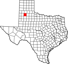 | |
| Town | ||
| CDP | ||
| Unincorporated community | ||
| Ghost town | ||
| Footnotes | ‡This populated place also has portions in an adjacent county or counties | |