Cotorro
| Cotorro | |
|---|---|
| Municipality of Havana | |
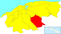 Location of Cotorro in Havana | |
| Coordinates: 23°01′34″N 82°14′51″W / 23.02611°N 82.24750°WCoordinates: 23°01′34″N 82°14′51″W / 23.02611°N 82.24750°W | |
| Country |
|
| Province |
|
| Wards (Consejos Populares) | Alberro, Cuatro Caminos, Lotería, San Pedro-Centro Cotorro, Santa Maria del Rosario, Magdalena-Torriente |
| Area[1] | |
| • Total | 66 km2 (25 sq mi) |
| Population (2004)[2] | |
| • Total | 74,650 |
| • Density | 1,131/km2 (2,930/sq mi) |
| Time zone | UTC-5 (EST) |
| Area code(s) | +53-7 |
Cotorro, or San Pedro del Cotorro, is one of the 15 municipalities (municipios in Spanish) in the city of Havana, Cuba.
Overview
The municipality is situated by the Carretera Central (Central Highway), and main autopista (motorway). Cotorro is 16 km from Old Havana. Its foundation dates to 1822. By the end of the 1950s, Cotorro had grown in such a way that it was exceeding in extension and population to the head of the municipality.
Twin towns – sister cities
References
- ↑ Statoids (July 2003). "Municipios of Cuba". Retrieved 2007-10-06.
- ↑ Atenas.cu (2004). "2004 Population trends, by Province and Municipality" (in Spanish). Archived from the original on 2006-07-14. Retrieved 2007-10-06.
External links
| Wikimedia Commons has media related to Cotorro. |
| Arroyo Naranjo |
| |
|---|---|---|
| Boyeros |
| |
| Centro Habana |
| |
| Cerro |
| |
| Cotorro |
| |
| Diez de Octubre |
| |
| Guanabacoa |
| |
| La Habana del Este |
| |
| La Habana Vieja |
| |
| La Lisa |
| |
| Marianao |
| |
| Playa |
| |
| Plaza de la Revolución |
| |
| Regla |
| |
| San Miguel del Padrón |
| |
This article is issued from
Wikipedia.
The text is licensed under Creative Commons - Attribution - Sharealike.
Additional terms may apply for the media files.