Corigliano Calabro
| Corigliano Calabro | |
|---|---|
| Frazione | |
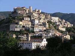 Panorama of Corigliano Calabro | |
 Corigliano Calabro Location of Corigliano Calabro in Italy | |
| Coordinates: 39°36′N 16°31′E / 39.600°N 16.517°ECoordinates: 39°36′N 16°31′E / 39.600°N 16.517°E | |
| Country |
|
| Region | Calabria |
| Province | Cosenza (CS) |
| Comune | Corigliano-Rossano |
| Area | |
| • Total | 196 km2 (76 sq mi) |
| Elevation | 210 m (690 ft) |
| Population (31 March 2017)[1] | |
| • Total | 40,428 |
| • Density | 210/km2 (530/sq mi) |
| Demonym(s) | Coriglianesi |
| Time zone | UTC+1 (CET) |
| • Summer (DST) | UTC+2 (CEST) |
| Postal code | 87064 |
| Dialing code | 0983 |
| Patron saint | Saint Francis of Paola |
| Saint day | April 25 |
| Website | Official website |
Corigliano Calabro is a town and a frazione of Corigliano-Rossano located in the province of Cosenza, c. 40 km northeast of the city of Cosenza, in Calabria, southern Italy.
Geography
It is situated near the mouth of a river of the same name, and contains an aqueduct. On an eminence overlooking the town is a feudal castle with massive towers and a deep trench.
In the comune are the ruins of the ancient city of Thurii, a former bishopric which remains a Latin titular see as Thurio. Nearby is Sibari, the site of the ancient city of Sybaris.
History
In 1879, it had a population of about 13,000. It had five churches, six convents, and a few public buildings. Licorice was made on a large scale, and there was a considerable trade in timber, wine, oranges, lemons and olives.
People
- Gennaro Gattuso, Italian footballer
- Francesco Serra, father of Brazilian politician José Serra
- Costantino Mortati, Italian constitutionalist
- Vincenzo Tieri, journalist, writer, playwright
- Aroldo Tieri, actor, son of the former
- Francesco Pianeta, boxer
References
Sources

| Wikimedia Commons has media related to Corigliano Calabro. |