Copley, Greater Manchester
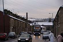
Huddersfield Road with St Paul's church in the background
Copley is an area of the town of Stalybridge,[1] at the foot of the Pennines, 8 miles (13 km) east of Manchester in Greater Manchester, England. The area has a local secondary school, Copley Academy, which is attached to a local recreational centre and swimming pool.
References
- ↑ Lancashire CV.NE (includes: Ashton Under Lyne; Dukinfield; Hartshead; Hurst; Mossley; Stalybridge.) (Map). Ordnance Survey. 1947. Retrieved 17 March 2018.
Coordinates: 53°42′N 1°52′W / 53.700°N 1.867°W
This article is issued from
Wikipedia.
The text is licensed under Creative Commons - Attribution - Sharealike.
Additional terms may apply for the media files.