Copenhagen metropolitan area
The Copenhagen metropolitan area or Metropolitan Copenhagen (Danish: Hovedstadsområdet, literally "The Capital Area") is a large commuter belt (the area in which it is practical to commute to work) surrounding Copenhagen, the capital of Denmark. It is known to include Copenhagen Municipality, Frederiksberg and surrounding municipalities stretching westward across Zealand. It has densely-populated core surrounded by suburban settlements.
According to OECD, the Copenhagen Metropolitan Region had close to 2.4 million inhabitants in 2005[1][2], which is the largest metropolitan area of any Scandinavian city.
The metropolitan area has several current definitions and also some historical, now defunct, definitions. The most widely accepted is the area which is strategically managed by the Finger Plan. The modern post 2007 version includes the four provinces Københavns by (Copenhagen city), Københavns omegn, Nordsjælland and Østsjælland, with a total land area of 2 778 km² and over 2 million inhabitants (16 March 2018;updated statistics from 1 January 2018 on cities (Danish byer, (singular) by) published later). [3] It should not be confused with the Øresund Region or the Capital Region of Denmark.
Finger Plan
.svg.png)
The area has been planned according to the Finger Plan, which has given it six fingers of S-trains and a western connection S-line (Ringbanen or line F). Urbanization stretching out from central Copenhagen. One railroad and two metro lines over Amager have been formed. The Amager railroad continues to Sweden by bridge.
Copenhagen metropolitan area is the largest of the commonly used definitions for the Copenhagen area. It has been defined administratively by the former Capital Region and is also known locally as HT-området (Capital Traffic area) because it is the zone where the capital traffic company formerly known as HT operates (now Movia), and is therefore the limit for how far you can go on a Copenhagen bus or train-ticket. Until 2007 the area consisted of Copenhagen and Frederiksberg Municipalities, Copenhagen County, Frederiksborg County and Roskilde County. After the municipality reform of Denmark 1 January 2007, the Danish counties were abolished and Vallø municipality which was a part of the metropolitan area was merged with Stevns municipality which was outside the metropolitan area and the new Stevns municipality became a part of the metropolitan area.[4]
Copenhagen metropolitan area now consists of 28 of the 29 municipalities of the Capital Region (all except Bornholm) as well as the municipalities of Greve, Køge, Lejre, Roskilde, Solrød and Stevns from the Region Zealand.
By this definition, the metropolitan area has a population of 2,016,285 (as of 1 January 2016) covering an area of 3,030 square kilometres (1,170 sq mi) over 34 municipalities with a density of 665/km² (1725/sq mi).[5][6]
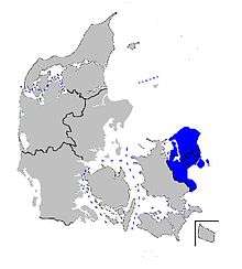
Capital Region of Denmark
The administrative entity responsible for the Capital Region of Denmark defines their administrative area as the metropolitan area of Copenhagen.[7] As such the population is 1,713,624 (1 October 2011) on an area of 2,561 km² with a density of 669.1/km² (1,733/sq mi).[8] It should however be noted that the Capital Region does not contain all of the Roskilde and Køge Bay fingers as well as all of the urban area which stretches into Region Zealand. Furthermore, it does contain the remote island of Bornholm.
Øresund Region
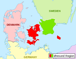
While actually a transnational region of co-operation, rather than a metropolitan area, the Øresund Region is by some considered to constitute the metropolitan area of Copenhagen.[9] This goes back to the Initiativgruppen (a group tasked for developing the Copenhagen area in 1989[10]), which was tasked with creating the metropole of the north.[11] As of 1 October 2011 the Øresund Region is populated by 3,783,158 inhabitants with a density of 181.3/km² (469.5/sq mi) (Danish side: 2,531,945, Swedish side: 1,251,213). According to OECD, however, this region includes vast areas which are not recognized as part of the functional metropolitan area.[1]
Core of the Øresund Region
Copenhagen is by far the largest city, and the obvious core of the region. However the Øresund Region covers large areas that are located remotely from both Copenhagen and the Øresund sea. Of which some has a rather low population density. Hence, a better area for comparacy with other regions, bi-lateral or national ones, is a lot narrower and includes the four Danish provinces Copenhagen by, Copenhagen omegn, Nordsjælland and Østsjælland with a total area of only 2.768,6 square kilometres[12] with 1,990,036 inhabitants as og 1.July 2014 [13] And on the Swedish side the 17 Scanian municipalities that either has direct border to the Øresund Sea or borders to a such municipality. (Bjuv, Burlöv, Eslöv, Helsingborg, Höganäs, Kävlinge, Landskrona, Lomma, Lund, Malmö, Staffanstorp, Svedala, Svalöv, Trelleborg, Vellinge, Åstorp and Ängelholm) These municipalities covers a total area of 3,201.3 square kilometres [14] and had a population of 941,409 inhabitants by 1.October 2014[15] A total population of 2,931,445 living at an aggregate area of 5,969.9 km2, with a population density of 491.0 inhabitants per km2 of land. This is an illustration of the population and population density around the Øresund sea rather than a formal area. But as such the population around Øresund constitutes by far the largest population centre of Scandinavia and Finland.
Copenhagen metropolitan area (within Denmark only)
Copenhagen metropolitan area is most commonly recognized, and before 2007 official, equal to the Danish part of this "core". The four mentioned Danish provinces, with two million inhabitants at a land area of 2.768,6 km2 and a population density of 722 people per square kilometre. While the administrational Region Hovedstaden includes the remote Baltic Sea island Bornholm, but excludes important suburbs south-west and west of the city as well as the locally important towns Køge and Roskilde which both are largely build together with the Danish capital through newer suburban areas.
Political reasons
Some Danish politicians simply do not want more than a third of the Danish Kingdom to be considered as parts of the capital, while remote areas on islands without fixed connections as well as parts of the windy North Sea coast get lower population figures. The 2007 regional and municipality reforms aimed to level figures out more evenly. Before 1970 there were 1098 Danish municipalities, between 1970 and 2006 this figure varied between 275 and 270. And by 2007 they were merged into just 98, however Copenhagen has not been allowed to include any new land area since 1902, despite Frederiksberg with 100,000+ inhabitants, on a 8.8 km2 surface, ever since 1901 has been an enclave totally surrounded by Copenhagen. For the last 114 years has Copenhagen municipality only grewn geographically through smaller enlargements from the sea. Also the waters around a sea mill park and areas which today is sea water but which either is a part of the harbour or planned enlargements for the future, are included in the size of the municipality (approx 86 km2).
OECD
OECD (Organisation for Economic Co-operation and Development) defines the Copenhagen metropolitan area with a population of 2,390,000 inhabitants as of 2009.[1] According to OECD the Finger Plan doesn't include the entire functional/economic metropolitan area of Copenhagen.
Other definitions
The local TV stations TV2/Lorry, Kanal København and Hovedstads-TV each also defines the Copenhagen metropolitan area as the area they respectively cover. They all fits well with the artea which the four provinces (Copenhagen by, Copenhagen omegn, Nordsjælland and Østsjælland) cover. (the provinces are based on European Union's so called NUTS 3 areas) The same area is used for the ticket fare system of all public transport within Greater Copenhagen and the Fingerplan area.
See also
References
- 1 2 3 "OECD: Territorial Review Copenhagen, 2009, p. 34". Københavns Kommune. Archived from the original on 19 January 2012.
- ↑ Same OECD 2008 report [OECD-rapport-om-hovedstadens-udvikling.pdf, page 34].
- ↑ Population projections 2013 by region/province, sex and age (select "provinces"). Retrieved 25 April 2016.
- ↑ 1.4.2. Hovedstadsudligningen Archived 13 February 2013 at Archive.is
- ↑ "BY1: Population 1. January by urban areas, age and sex". statbank.dk. Statistics Denmark. Retrieved 22 April 2016.
- ↑ Map of the Capital Municipalities Archived 15 December 2012 at the Wayback Machine.
- ↑ "Vækstforum, Region Hovedstaden" (PDF) (in Danish). 17 July 2007. Retrieved 23 January 2012.
- ↑ "Statistikbanken". statistikbanken.dk.
- ↑ "City Mayors: Danish and Swedish regions gave up power to create bi-national metropolis". City Mayors. Archived from the original on 26 January 2012. Retrieved 26 January 2012.
- ↑ "Øresundstid" (in Danish). Retrieved 23 January 2012.
- ↑ Kresl, Peter Karl (2007). Planning cities for the future. Edward Elgard Publishing. p. 101. ISBN 978-1-84542-530-2.
- ↑ "Areal". Dst.dk. Retrieved 15 December 2017.
- ↑ "Befolkning og befolkningsfremskrivning". Dst.dk. Retrieved 15 December 2017.
- ↑ "Land- och vattenareal per den 1 januari efter region och arealtyp. År 2012 - 2017". Statistikdatabasen.scb.se. Retrieved 15 December 2017.
- ↑ "Archived copy". Archived from the original on 20 March 2015. Retrieved 12 March 2015.