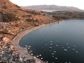
Copacabana Municipality, La Paz
| Copacabana Municipality | |
|---|---|
| Municipality | |
 | |
 Copacabana Municipality Location of the Arani Municipality within Bolivia | |
| Coordinates: 16°9′0″S 69°2′0″W / 16.15000°S 69.03333°WCoordinates: 16°9′0″S 69°2′0″W / 16.15000°S 69.03333°W | |
| Country |
|
| Department | La Paz Department |
| Province | Manco Kapac Province |
| Seat | Copacabana |
| Government | |
| • Mayor | Juan Armando Callisaya Quispe |
| • President | Adela Calizaya de Mamani |
| Area | |
| • Total | 67 sq mi (174 km2) |
| Elevation | 12,630 ft (3,850 m) |
| Population (2001) | |
| • Total | 14,586 |
| • Ethnicities | Aymara |
| Time zone | UTC-5 (EST) |
| • Summer (DST) | UTC-4 (EDT) |
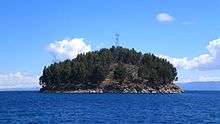
Chelleca island, Lake Titicaca
Copacabana Municipality is the first municipal section of the Manco Kapac Province in the La Paz Department, Bolivia. Its capital is Copacabana.
Isla del Sol (Island of the Sun) and Chelleca island are situated within the municipality.
Subdivision
The municipality is divided into three cantons.
| Canton | Inhabitants (2001)[1] | Seat |
|---|---|---|
| Copacabana Canton | 8,194 | Copacabana |
| Lokha Canton | 2,388 | Lokha |
| Zampaya Canton | 4,004 | Zampaya |
The people
The people are predominantly indigenous citizens of Aymaran descent.
| Ethnic group | % |
|---|---|
| Quechua | 0.9 |
| Aymara | 95.9 |
| Guaraní, Chiquitos, Moxos | 0.2 |
| Not indigenous | 3.0 |
| Other indigenous groups | 0.1 |
Ref.: obd.descentralizacion.gov.bo
Languages
The languages spoken in the Copacabana Municipality are mainly Aymara and Spanish.
| Language | Inhabitants |
|---|---|
| Quechua | 185 |
| Aymara | 11,825 |
| Guaraní | 6 |
| Another native | 4 |
| Spanish | 10,713 |
| Foreign | 81 |
| Only native | 3,020 |
| Native and Spanish | 8,858 |
| Only Spanish | 1,857 |
Places of interest
See also
References
- ↑ www.ine.gob.bo Archived September 24, 2011, at the Wayback Machine.
External links

This article is issued from
Wikipedia.
The text is licensed under Creative Commons - Attribution - Sharealike.
Additional terms may apply for the media files.