Coosa, Georgia
| Coosa, Georgia | |
|---|---|
| Unincorporated community | |
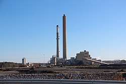 Plant Hammond, a coal-fired power plant in Coosa | |
 Coosa | |
| Coordinates: 34°15′16″N 85°21′16″W / 34.25444°N 85.35444°WCoordinates: 34°15′16″N 85°21′16″W / 34.25444°N 85.35444°W | |
| Country | United States |
| State | Georgia |
| County | Floyd |
| Elevation | 594 ft (181 m) |
| Time zone | UTC-5 (Eastern (EST)) |
| • Summer (DST) | UTC-4 (EDT) |
| ZIP code | 30129 |
| Area code(s) | 770, 678, 470 |
| GNIS feature ID | 355297[1] |
Coosa is an unincorporated community in Floyd County, Georgia, United States. The community is located at the intersection of Georgia routes 20 and 100, north of the Coosa River, 11 miles (18 km) west of Rome. Coosa has a post office with ZIP code 30129, which opened on December 28, 1846.[2][3] An early variant name was "Missionary Station".[4]
References
| Wikimedia Commons has media related to Coosa, Georgia. |
- ↑ "Coosa". Geographic Names Information System. United States Geological Survey.
- ↑ United States Postal Service. "USPS - Look Up a ZIP Code". Retrieved May 28, 2015.
- ↑ "Postmaster Finder - Post Offices by ZIP Code". United States Postal Service. Retrieved May 28, 2015.
- ↑ Krakow, Kenneth K. (1975). Georgia Place-Names: Their History and Origins (PDF). Macon, GA: Winship Press. p. 51. ISBN 0-915430-00-2.
Municipalities and communities of Floyd County, Georgia, United States | ||
|---|---|---|
| Cities | 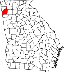 | |
| CDPs | ||
| Unincorporated communities | ||
This article is issued from
Wikipedia.
The text is licensed under Creative Commons - Attribution - Sharealike.
Additional terms may apply for the media files.