Coornhoop
Coornhoop (also Koornhoop, Corenhoop, Coorenhoop) is a historic 17th century farmhouse.[1] It is located at 2 Dixton Road in Observatory, Cape Town. Currently, it houses the Centre for Conflict Resolution.
History
In 1657 and 1658, Jan van Riebeeck gave land to 14 Vryburgers on the western bank of the Liesbeek to farm with wheat.[2] To protect their harvest from raids by the Khoikhoi, a row of forts and sheds were built along the river. In September 1657 the sheds were completed at Coornhoop.[3][4] Should an attack be threatened, the women and children of the nearby fields had to hide in it. After 4 years, the buildings at Coornhoop expired. A whole series of owners then subdivided the ground and sometimes consolidated pieces and cultivated the shrubs to the house.[5] It has evolved into one of Cape Peninsula's most beautiful developments. In the 19th and 20th centuries the buildings decayed and were demolished.[6]
Architecture
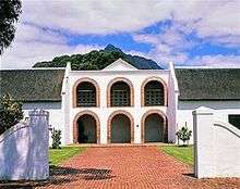
In 1961, the Simon van der Stel Foundation[lower-alpha 1] bought the buildings and rebuilt in 1964.[6] The endwalls of the remaining shells are of the hollow ball type and date from 1797.
Dovecot
Behind two rows of each of the three arches stands a unique double-storey dovecot. It connects two of the original sheds. The front view is a feature of the Cape architecture. In 1966 only this dovecot was declared a memorial. In the William Fehr Collection there is a sketch from 1896 by A.F. Truter of the dovecot.[7]
Western Province Agricultural Union
On May 24, 1971, the agricultural union made an information board for the building listing the names of the first 14 free burghers located at Coornhoop, De Hollantse Thuijn and Groenevelt.[8]
References
Notes
- ↑ Cook 2004, pp. 92-93.
- ↑ Spies & du Plessis 1976, §4, pp. 75-76 §6, p. 442.
- ↑ Sleigh 1996, pp. 40-42.
- ↑ Pama 1979, p. 47.
- ↑ Simons 1987, p. 30-34.
- 1 2 Oberholster 1972, p. 42.
- ↑ Walton 1989, pp. 108-109.
- ↑ Anon 1971.
Sources
- Anon (1971). Coornhoop, 24-5-1971: Free Burgher - Commemoration Day. Simon Van Der Stel Foundation.
- Athiros, Gabriel; Athiros, Louise (2007). Woodstock: a selection of articles from The Woodstock Whisperer, 2003 - 2007. Historical Media. ISBN 978-0-620-39924-1.
- Cook, Mary Alexander (2004). A Guide to the Old Buildings of the Cape: A Survey of Extant Architecture from Before C1910 in the Area of Cape Town-Calvinia-Colesberg-Uitenhage. Jonathan Ball Publishers. ISBN 978-1-86842-191-6.
- Oberholster, J. J. (1972). The historical monuments of South Africa. National Monuments Council. ISBN 978-0-620-00192-2 – via Rembrandt Van Rijn Foundation for Culture.
- Pama, C. (1979). Wagon Road to Wynberg. Tafelberg. ISBN 978-0-624-01001-2.
- Simons, Phillida Brooke (1987). Cape Dutch houses: a concise guide. C. Struik. ISBN 978-0-86977-427-4.
- Sleigh, Dan (1996). The forts of the Liesbeeck frontier. Castle Military Museum.
- Spies, J. J.; du Plessis, P. C., eds. (1976). Standard Encyclopaedia of Southern Africa. Capetown: Nasou.
- van Bart, Martiens (29 November 2003). "Hoop vir De Coornhoop?" [Hope for the Coornhoop?]. Die Burger (in Afrikaans).
- Walton, James (1989). Old Cape Farmsteads. Human & Rousseau. ISBN 978-0-7981-2592-5.
Coordinates: 33°56′36″S 18°28′32″E / 33.943408°S 18.475474°E