Coolmine


Coolmine (Irish: Cúl Mhín) is a residential area in Fingal, Ireland. It is also a townland in the civil parish of Clonsilla.[1]
Location and access
Coolmine is located between the suburban areas of Blanchardstown (to the south-east) and Clonsilla (to the west). It is in the Dublin 15 postal district. It is roughly 15 kilometres from Dublin city. One of the largest shopping outlets in Ireland - the Blanchardstown Centre - is located in the townland.
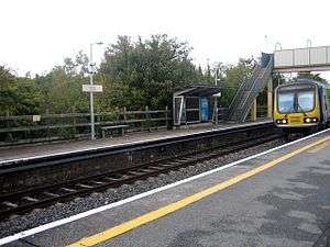
Public transport in Coolmine is provided by Dublin Bus and a train station on the Maynooth/M3 Parkway Western Commuter line. Coolmine railway station was opened on 2 July 1990.[2] Those Dublin Bus routes serving Coolmine are 37 & 39. The N3 Navan Road is the main road artery.
Amenities
Coolmine Woods
In the centre of Coolmine is the Coolmine woods. Its main path is often used as a shortcut for people heading towards the Blanchardstown Shopping Centre or by schoolchildren attending Coolmine Community School. The woods offers a pleasant and peaceful atmosphere away from the noise and traffic of the busy roads of Coolmine. Its flat and open grass make it popular for joggers and dog-walkers while during the summer, local football teams train on the grass.
Millennium Park
The Millennium Park is located between Coolmine and the Blanchardstown Shopping Centre. The park is run by Fingal County Council and its amenities include two all weather astro pitches, a children's playground, dog pen, skatepark, and exercise stations.
Enterprise
Coolmine Industrial Estate was opened on 30 May 1983 by Councillor Michael Gannon. The estate is home to a number or businesses and services such as a Post Office, the Blanchardstown Fire Station and several small businesses. There are a number of tertiary services in the industrial estate.
See also
References
| Wikimedia Commons has media related to Coolmine. |
- ↑ Placenames Database of Ireland - Coolmine townland
- ↑ "Coolmine station" (PDF). Railscot - Irish Railways. Retrieved 2007-08-31.
Coordinates: 53°23′04″N 6°23′40″W / 53.384489°N 6.394485°W