Contin Island
| Gaelic name | Eilean Chunndainn |
|---|---|
| Meaning of name | island of Contin |
| Location | |
 Contin Island Contin Island shown within Ross and Cromarty | |
| OS grid reference | NH457556 |
| Coordinates | 57°34′05″N 4°34′26″W / 57.568°N 4.5738°W |
| Physical geography | |
| Island group | River Conon |
| Area | c. 15 hectares (37 acres) |
| Highest elevation | 20 m (66 ft) above sea level[1] |
| Administration | |
| Sovereign state | United Kingdom |
| Country | Scotland |
| Council area | Highland |
| Demographics | |
| Population | approx 3 (2011) |
Contin Island is an inhabited riverine islet in Ross and Cromarty within the Highland Council area of Scotland. Located in the Black Water, a tributary of the River Conon, it is 2 kilometres (1.2 mi) downstream from Rogie Falls and is connected to the village of Contin by both a road bridge and a footbridge.[1]
Geography
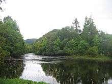
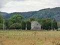
The island is flat and lies between two arms of the Black Water. It is wooded at the northern and southern ends and at the center is the parish church of Contin, dedicated to St Maelrubha or Máel Ruba and the old manse, surrounded by farm land. There has probably been a church on this site since the 7th or 8th century and there is a reference to it in 1227. The present church building dates from 1490, the former church having been burned by the MacDonalds sometime between 1482 and 1488. It was repaired and altered circa 1832. There are two stones in the churchyard dating to about 1200.[1][2][3]
The church itself is constructed with rubble walls and a slate roof and the 19th century reconstruction was done to the design of William Thomson. It has arched doors, windows with lattice glazing and a birdcage bellcote on the west gable.[4]
The manse, constructed in 1794 and enlarged in the 19th century, is located to the south of the church.[5] It is now a private dwelling.
Inhabitation
Although it is clear from photographic evidence that the island is inhabited, at least from time to time, it was not listed as such by the census in 2001. However, the manse is a full-time family home. [6] or 2011.[7]
See also
Gallery
 Contin Church
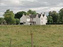 Contin Manse
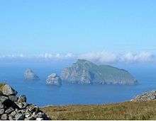
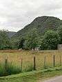 The heights of Torr Achilty from Contin Island
Footnotes
- 1 2 3 "Get-a-map" Ordnance Survey. Retrieved 11 August 2012.
- ↑ "Contin Church". Contin: Highland Village. Retrieved 11 August 2012.
- ↑ "Contin, Church of Scotland Parish Church". Canmore. Retrieved 11 August 2012.
- ↑ "Strathconon Parish Church". Scottish Church Heritage Research. Retrieved 11 August 2012.
- ↑ New Statistical Account xiv p. 242
- ↑ General Register Office for Scotland (28 Nov 2003) Occasional Paper No 10: Statistics for Inhabited Islands Archived 2011-11-22 at the Wayback Machine.. Retrieved 26 Feb 2012.
- ↑ National Records of Scotland (15 August 2013) (pdf) Statistical Bulletin: 2011 Census: First Results on Population and Household Estimates for Scotland - Release 1C (Part Two). "Appendix 2: Population and households on Scotland’s inhabited islands". Retrieved 17 August 2013.
|  | ||||||||||||||||
|
| |||||||||||||||||
| |||||||||||||||||
| |||||||||||||||||
| |||||||||||||||||
| |||||||||||||||||
| |||||||||||||||||
| |||||||||||||||||